You are here: Home > Network List > TA - USArray Transportable Network (new EarthScope stations) Stations List
> Station D25K Kavik River, AK, USA > Earthquake Result Viewer
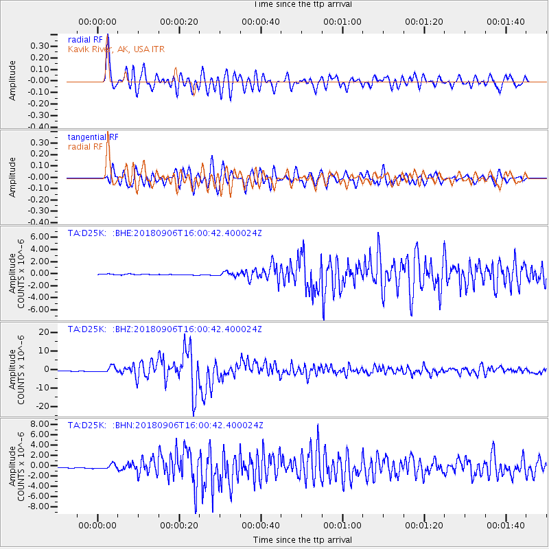
D25K Kavik River, AK, USA - Earthquake Result Viewer
*The percent match for this event was below the threshold and hence no stack was calculated.
| Earthquake location: |
Fiji Islands |
| Earthquake latitude/longitude: |
-18.4/179.5 |
| Earthquake time(UTC): |
2018/09/06 (249) 15:49:17 GMT |
| Earthquake Depth: |
669 km |
| Earthquake Magnitude: |
8.1 Mi |
| Earthquake Catalog/Contributor: |
NEIC PDE/at |
|
| Network: |
TA USArray Transportable Network (new EarthScope stations) |
| Station: |
D25K Kavik River, AK, USA |
| Lat/Lon: |
69.32 N/146.38 W |
| Elevation: |
770 m |
|
| Distance: |
90.8 deg |
| Az: |
11.495 deg |
| Baz: |
212.19 deg |
| Ray Param: |
$rayparam |
*The percent match for this event was below the threshold and hence was not used in the summary stack. |
|
| Radial Match: |
91.202644 % |
| Radial Bump: |
400 |
| Transverse Match: |
91.1216 % |
| Transverse Bump: |
400 |
| SOD ConfigId: |
13570011 |
| Insert Time: |
2019-05-01 03:24:08.135 +0000 |
| GWidth: |
2.5 |
| Max Bumps: |
400 |
| Tol: |
0.001 |
|
Signal To Noise
| Channel | StoN | STA | LTA |
| TA:D25K: :BHZ:20180906T16:00:42.400024Z | 12.229152 | 1.5834603E-6 | 1.2948243E-7 |
| TA:D25K: :BHN:20180906T16:00:42.400024Z | 5.812148 | 4.3535022E-7 | 7.49035E-8 |
| TA:D25K: :BHE:20180906T16:00:42.400024Z | 4.9859447 | 2.9423043E-7 | 5.901197E-8 |
| Arrivals |
| Ps | |
| PpPs | |
| PsPs/PpSs | |


