You are here: Home > Network List > TA - USArray Transportable Network (new EarthScope stations) Stations List
> Station E20K Nigu River, AK, USA > Earthquake Result Viewer
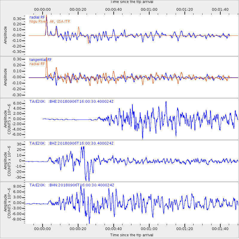
E20K Nigu River, AK, USA - Earthquake Result Viewer
*The percent match for this event was below the threshold and hence no stack was calculated.
| Earthquake location: |
Fiji Islands |
| Earthquake latitude/longitude: |
-18.4/179.5 |
| Earthquake time(UTC): |
2018/09/06 (249) 15:49:17 GMT |
| Earthquake Depth: |
669 km |
| Earthquake Magnitude: |
8.1 Mi |
| Earthquake Catalog/Contributor: |
NEIC PDE/at |
|
| Network: |
TA USArray Transportable Network (new EarthScope stations) |
| Station: |
E20K Nigu River, AK, USA |
| Lat/Lon: |
68.26 N/156.19 W |
| Elevation: |
866 m |
|
| Distance: |
88.2 deg |
| Az: |
8.828 deg |
| Baz: |
203.023 deg |
| Ray Param: |
$rayparam |
*The percent match for this event was below the threshold and hence was not used in the summary stack. |
|
| Radial Match: |
93.0444 % |
| Radial Bump: |
400 |
| Transverse Match: |
88.33564 % |
| Transverse Bump: |
400 |
| SOD ConfigId: |
13570011 |
| Insert Time: |
2019-05-01 03:24:12.887 +0000 |
| GWidth: |
2.5 |
| Max Bumps: |
400 |
| Tol: |
0.001 |
|
Signal To Noise
| Channel | StoN | STA | LTA |
| TA:E20K: :BHZ:20180906T16:00:30.400024Z | 16.29007 | 2.8484462E-6 | 1.7485782E-7 |
| TA:E20K: :BHN:20180906T16:00:30.400024Z | 3.7802389 | 6.2851217E-7 | 1.6626255E-7 |
| TA:E20K: :BHE:20180906T16:00:30.400024Z | 2.920498 | 3.3733986E-7 | 1.1550766E-7 |
| Arrivals |
| Ps | |
| PpPs | |
| PsPs/PpSs | |


