You are here: Home > Network List > TA - USArray Transportable Network (new EarthScope stations) Stations List
> Station G22K Bettles, AK, USA > Earthquake Result Viewer
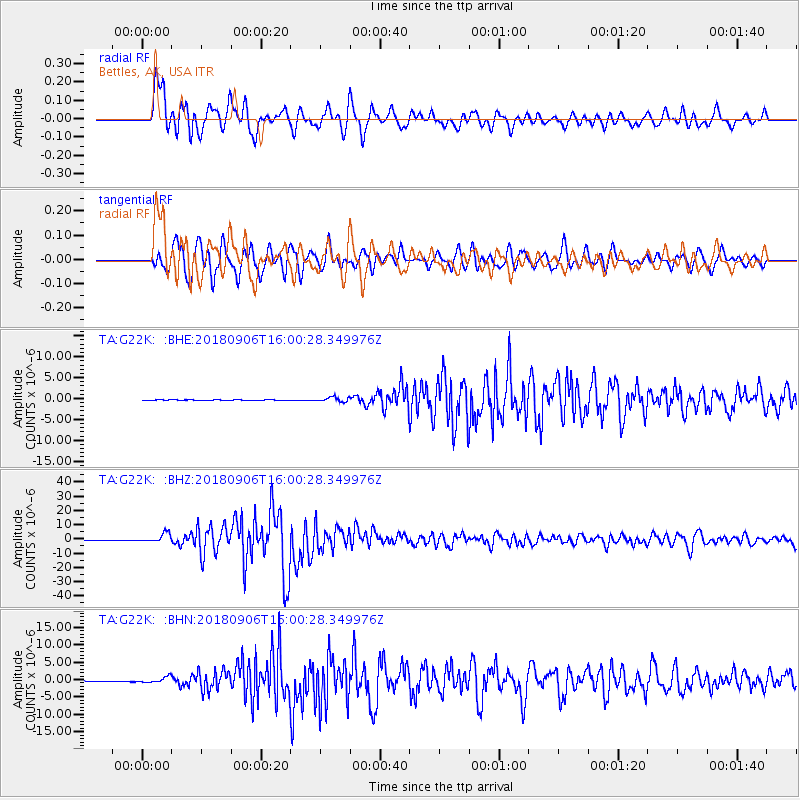
G22K Bettles, AK, USA - Earthquake Result Viewer
*The percent match for this event was below the threshold and hence no stack was calculated.
| Earthquake location: |
Fiji Islands |
| Earthquake latitude/longitude: |
-18.4/179.5 |
| Earthquake time(UTC): |
2018/09/06 (249) 15:49:17 GMT |
| Earthquake Depth: |
669 km |
| Earthquake Magnitude: |
8.1 Mi |
| Earthquake Catalog/Contributor: |
NEIC PDE/at |
|
| Network: |
TA USArray Transportable Network (new EarthScope stations) |
| Station: |
G22K Bettles, AK, USA |
| Lat/Lon: |
66.92 N/151.51 W |
| Elevation: |
205 m |
|
| Distance: |
87.8 deg |
| Az: |
11.024 deg |
| Baz: |
207.424 deg |
| Ray Param: |
$rayparam |
*The percent match for this event was below the threshold and hence was not used in the summary stack. |
|
| Radial Match: |
92.91318 % |
| Radial Bump: |
400 |
| Transverse Match: |
92.58116 % |
| Transverse Bump: |
400 |
| SOD ConfigId: |
13570011 |
| Insert Time: |
2019-05-01 03:24:31.923 +0000 |
| GWidth: |
2.5 |
| Max Bumps: |
400 |
| Tol: |
0.001 |
|
Signal To Noise
| Channel | StoN | STA | LTA |
| TA:G22K: :BHZ:20180906T16:00:28.349976Z | 21.005234 | 3.1873524E-6 | 1.5174088E-7 |
| TA:G22K: :BHN:20180906T16:00:28.349976Z | 9.403357 | 8.535188E-7 | 9.076746E-8 |
| TA:G22K: :BHE:20180906T16:00:28.349976Z | 7.788057 | 4.2824956E-7 | 5.498799E-8 |
| Arrivals |
| Ps | |
| PpPs | |
| PsPs/PpSs | |


