You are here: Home > Network List > TA - USArray Transportable Network (new EarthScope stations) Stations List
> Station M11K Mekoryuk, AK, USA > Earthquake Result Viewer
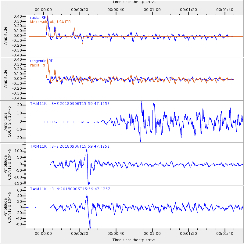
M11K Mekoryuk, AK, USA - Earthquake Result Viewer
*The percent match for this event was below the threshold and hence no stack was calculated.
| Earthquake location: |
Fiji Islands |
| Earthquake latitude/longitude: |
-18.4/179.5 |
| Earthquake time(UTC): |
2018/09/06 (249) 15:49:17 GMT |
| Earthquake Depth: |
669 km |
| Earthquake Magnitude: |
8.1 Mi |
| Earthquake Catalog/Contributor: |
NEIC PDE/at |
|
| Network: |
TA USArray Transportable Network (new EarthScope stations) |
| Station: |
M11K Mekoryuk, AK, USA |
| Lat/Lon: |
60.38 N/166.20 W |
| Elevation: |
3.0 m |
|
| Distance: |
79.4 deg |
| Az: |
7.17 deg |
| Baz: |
193.805 deg |
| Ray Param: |
$rayparam |
*The percent match for this event was below the threshold and hence was not used in the summary stack. |
|
| Radial Match: |
95.57057 % |
| Radial Bump: |
400 |
| Transverse Match: |
93.80164 % |
| Transverse Bump: |
400 |
| SOD ConfigId: |
13570011 |
| Insert Time: |
2019-05-01 03:25:15.496 +0000 |
| GWidth: |
2.5 |
| Max Bumps: |
400 |
| Tol: |
0.001 |
|
Signal To Noise
| Channel | StoN | STA | LTA |
| TA:M11K: :BHZ:20180906T15:59:47.125Z | 22.95062 | 6.3477155E-6 | 2.7658143E-7 |
| TA:M11K: :BHN:20180906T15:59:47.125Z | 7.5941644 | 1.552485E-6 | 2.044313E-7 |
| TA:M11K: :BHE:20180906T15:59:47.125Z | 2.6008294 | 4.6743298E-7 | 1.797246E-7 |
| Arrivals |
| Ps | |
| PpPs | |
| PsPs/PpSs | |


