You are here: Home > Network List > TA - USArray Transportable Network (new EarthScope stations) Stations List
> Station K27A Flueckinger Farm, Gordon, NE, USA > Earthquake Result Viewer
K27A Flueckinger Farm, Gordon, NE, USA - Earthquake Result Viewer
| Earthquake location: |
Near S. Coast Of Honshu, Japan |
| Earthquake latitude/longitude: |
33.2/137.9 |
| Earthquake time(UTC): |
2009/08/09 (221) 10:55:55 GMT |
| Earthquake Depth: |
297 km |
| Earthquake Magnitude: |
6.5 MB, 7.1 MW, 7.1 MW |
| Earthquake Catalog/Contributor: |
WHDF/NEIC |
|
| Network: |
TA USArray Transportable Network (new EarthScope stations) |
| Station: |
K27A Flueckinger Farm, Gordon, NE, USA |
| Lat/Lon: |
42.70 N/102.24 W |
| Elevation: |
1131 m |
|
| Distance: |
86.5 deg |
| Az: |
39.843 deg |
| Baz: |
313.196 deg |
| Ray Param: |
0.043248575 |
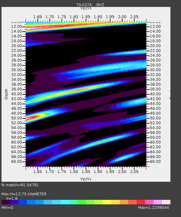
| Estimated Moho Depth: |
12.75 km |
| Estimated Crust Vp/Vs: |
1.60 |
| Assumed Crust Vp: |
6.483 km/s |
| Estimated Crust Vs: |
4.052 km/s |
| Estimated Crust Poisson's Ratio: |
0.18 |
|
| Radial Match: |
91.54791 % |
| Radial Bump: |
398 |
| Transverse Match: |
85.64735 % |
| Transverse Bump: |
400 |
| SOD ConfigId: |
2622 |
| Insert Time: |
2010-03-06 15:20:53.057 +0000 |
| GWidth: |
2.5 |
| Max Bumps: |
400 |
| Tol: |
0.001 |
|

Signal To Noise
| Channel | StoN | STA | LTA |
| TA:K27A: :BHZ:20090809T11:07:34.125015Z | 110.44889 | 7.769388E-6 | 7.034374E-8 |
| TA:K27A: :BHN:20090809T11:07:34.125015Z | 11.236074 | 1.8425742E-6 | 1.6398737E-7 |
| TA:K27A: :BHE:20090809T11:07:34.125015Z | 14.259588 | 1.7037019E-6 | 1.1947763E-7 |
| Arrivals |
| Ps | 1.2 SECOND |
| PpPs | 5.0 SECOND |
| PsPs/PpSs | 6.2 SECOND |


