You are here: Home > Network List > TA - USArray Transportable Network (new EarthScope stations) Stations List
> Station K27A Flueckinger Farm, Gordon, NE, USA > Earthquake Result Viewer
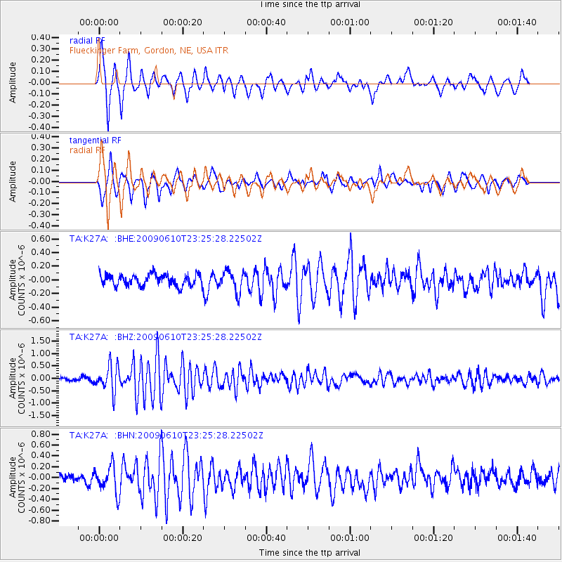
K27A Flueckinger Farm, Gordon, NE, USA - Earthquake Result Viewer

| Earthquake location: |
West Chile Rise |
| Earthquake latitude/longitude: |
-41.7/-84.0 |
| Earthquake time(UTC): |
2009/06/10 (161) 23:13:21 GMT |
| Earthquake Depth: |
10 km |
| Earthquake Magnitude: |
5.7 MB, 5.2 MS, 5.7 MW, 5.6 MW |
| Earthquake Catalog/Contributor: |
WHDF/NEIC |
|
| Network: |
TA USArray Transportable Network (new EarthScope stations) |
| Station: |
K27A Flueckinger Farm, Gordon, NE, USA |
| Lat/Lon: |
42.70 N/102.24 W |
| Elevation: |
1131 m |
|
| Distance: |
85.6 deg |
| Az: |
346.62 deg |
| Baz: |
166.407 deg |
| Ray Param: |
0.044624966 |
| Estimated Moho Depth: |
62.0 km |
| Estimated Crust Vp/Vs: |
1.73 |
| Assumed Crust Vp: |
6.483 km/s |
| Estimated Crust Vs: |
3.758 km/s |
| Estimated Crust Poisson's Ratio: |
0.25 |
|
| Radial Match: |
80.70099 % |
| Radial Bump: |
400 |
| Transverse Match: |
72.6137 % |
| Transverse Bump: |
400 |
| SOD ConfigId: |
2648 |
| Insert Time: |
2010-03-06 15:21:04.489 +0000 |
| GWidth: |
2.5 |
| Max Bumps: |
400 |
| Tol: |
0.001 |
|
Signal To Noise
| Channel | StoN | STA | LTA |
| TA:K27A: :BHZ:20090610T23:25:28.22502Z | 6.701301 | 5.414018E-7 | 8.079055E-8 |
| TA:K27A: :BHN:20090610T23:25:28.22502Z | 3.2720864 | 2.548637E-7 | 7.789027E-8 |
| TA:K27A: :BHE:20090610T23:25:28.22502Z | 1.9273084 | 1.611517E-7 | 8.36149E-8 |
| Arrivals |
| Ps | 7.1 SECOND |
| PpPs | 25 SECOND |
| PsPs/PpSs | 33 SECOND |


