You are here: Home > Network List > TA - USArray Transportable Network (new EarthScope stations) Stations List
> Station K27A Flueckinger Farm, Gordon, NE, USA > Earthquake Result Viewer
K27A Flueckinger Farm, Gordon, NE, USA - Earthquake Result Viewer
| Earthquake location: |
Tonga Islands Region |
| Earthquake latitude/longitude: |
-23.0/-174.7 |
| Earthquake time(UTC): |
2009/03/19 (078) 18:17:40 GMT |
| Earthquake Depth: |
34 km |
| Earthquake Magnitude: |
7.0 MB, 7.6 MS, 7.6 MW, 7.6 MW |
| Earthquake Catalog/Contributor: |
WHDF/NEIC |
|
| Network: |
TA USArray Transportable Network (new EarthScope stations) |
| Station: |
K27A Flueckinger Farm, Gordon, NE, USA |
| Lat/Lon: |
42.70 N/102.24 W |
| Elevation: |
1131 m |
|
| Distance: |
93.3 deg |
| Az: |
44.741 deg |
| Baz: |
241.595 deg |
| Ray Param: |
0.04127193 |
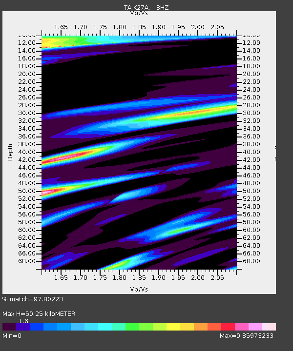
| Estimated Moho Depth: |
50.25 km |
| Estimated Crust Vp/Vs: |
1.60 |
| Assumed Crust Vp: |
6.483 km/s |
| Estimated Crust Vs: |
4.052 km/s |
| Estimated Crust Poisson's Ratio: |
0.18 |
|
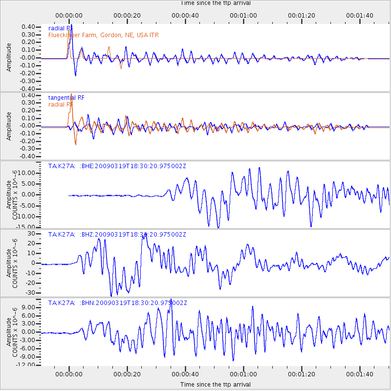
| Radial Match: |
97.80223 % |
| Radial Bump: |
400 |
| Transverse Match: |
94.40229 % |
| Transverse Bump: |
400 |
| SOD ConfigId: |
2658 |
| Insert Time: |
2010-03-06 15:21:09.700 +0000 |
| GWidth: |
2.5 |
| Max Bumps: |
400 |
| Tol: |
0.001 |
|
Signal To Noise
| Channel | StoN | STA | LTA |
| TA:K27A: :BHZ:20090319T18:30:20.975002Z | 20.774225 | 4.1285944E-6 | 1.9873639E-7 |
| TA:K27A: :BHN:20090319T18:30:20.975002Z | 4.6027775 | 6.326048E-7 | 1.374398E-7 |
| TA:K27A: :BHE:20090319T18:30:20.975002Z | 7.1007442 | 1.1664309E-6 | 1.6426883E-7 |
| Arrivals |
| Ps | 4.8 SECOND |
| PpPs | 20 SECOND |
| PsPs/PpSs | 24 SECOND |


