You are here: Home > Network List > UW - Pacific Northwest Regional Seismic Network Stations List
> Station UMAT Pilot Rock, OR, USA > Earthquake Result Viewer
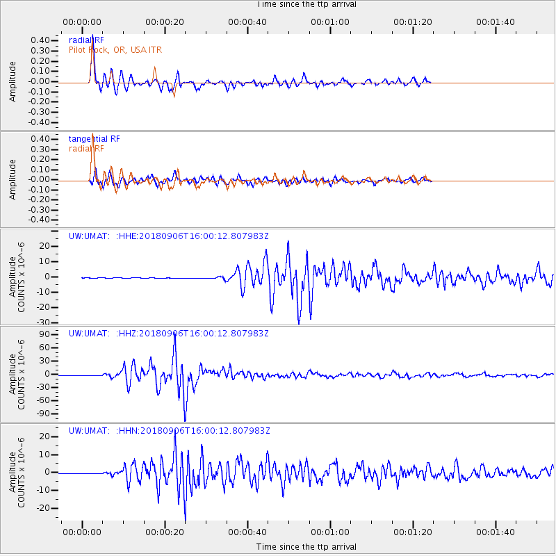
UMAT Pilot Rock, OR, USA - Earthquake Result Viewer
*The percent match for this event was below the threshold and hence no stack was calculated.
| Earthquake location: |
Fiji Islands |
| Earthquake latitude/longitude: |
-18.4/179.5 |
| Earthquake time(UTC): |
2018/09/06 (249) 15:49:17 GMT |
| Earthquake Depth: |
669 km |
| Earthquake Magnitude: |
8.1 Mi |
| Earthquake Catalog/Contributor: |
NEIC PDE/at |
|
| Network: |
UW Pacific Northwest Regional Seismic Network |
| Station: |
UMAT Pilot Rock, OR, USA |
| Lat/Lon: |
45.29 N/118.96 W |
| Elevation: |
1318 m |
|
| Distance: |
84.4 deg |
| Az: |
38.575 deg |
| Baz: |
237.007 deg |
| Ray Param: |
$rayparam |
*The percent match for this event was below the threshold and hence was not used in the summary stack. |
|
| Radial Match: |
97.05729 % |
| Radial Bump: |
348 |
| Transverse Match: |
91.19291 % |
| Transverse Bump: |
400 |
| SOD ConfigId: |
13570011 |
| Insert Time: |
2019-05-01 03:27:34.156 +0000 |
| GWidth: |
2.5 |
| Max Bumps: |
400 |
| Tol: |
0.001 |
|
Signal To Noise
| Channel | StoN | STA | LTA |
| UW:UMAT: :HHZ:20180906T16:00:12.807983Z | 3.7630918 | 4.938442E-7 | 1.3123363E-7 |
| UW:UMAT: :HHN:20180906T16:00:12.807983Z | 2.1862698 | 1.5913099E-7 | 7.2786534E-8 |
| UW:UMAT: :HHE:20180906T16:00:12.807983Z | 2.736165 | 1.9276729E-7 | 7.045163E-8 |
| Arrivals |
| Ps | |
| PpPs | |
| PsPs/PpSs | |


