You are here: Home > Network List > TA - USArray Transportable Network (new EarthScope stations) Stations List
> Station K27A Flueckinger Farm, Gordon, NE, USA > Earthquake Result Viewer
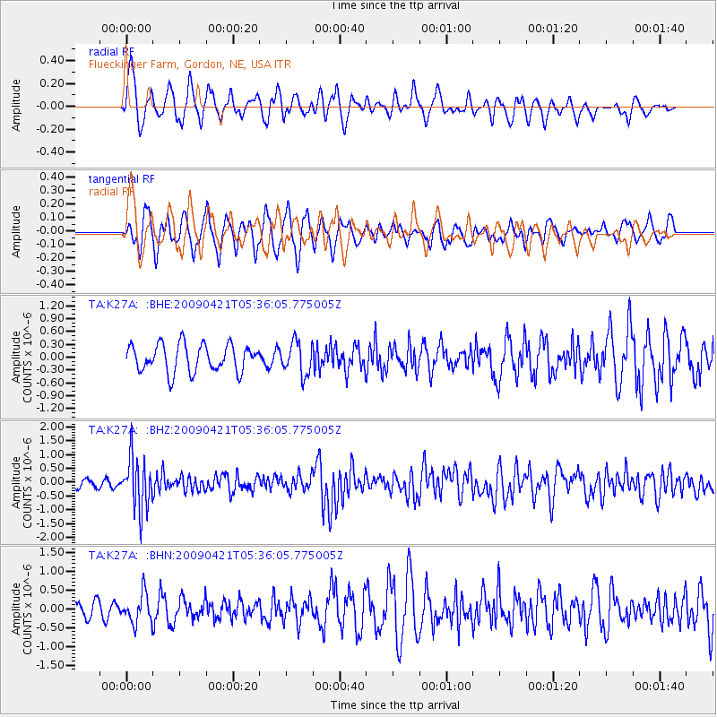
K27A Flueckinger Farm, Gordon, NE, USA - Earthquake Result Viewer
*The percent match for this event was below the threshold and hence no stack was calculated.
| Earthquake location: |
Kuril Islands |
| Earthquake latitude/longitude: |
50.8/155.0 |
| Earthquake time(UTC): |
2009/04/21 (111) 05:26:11 GMT |
| Earthquake Depth: |
152 km |
| Earthquake Magnitude: |
6.0 MB, 6.2 MW, 6.2 MW |
| Earthquake Catalog/Contributor: |
WHDF/NEIC |
|
| Network: |
TA USArray Transportable Network (new EarthScope stations) |
| Station: |
K27A Flueckinger Farm, Gordon, NE, USA |
| Lat/Lon: |
42.70 N/102.24 W |
| Elevation: |
1131 m |
|
| Distance: |
65.2 deg |
| Az: |
52.366 deg |
| Baz: |
317.057 deg |
| Ray Param: |
$rayparam |
*The percent match for this event was below the threshold and hence was not used in the summary stack. |
|
| Radial Match: |
70.105774 % |
| Radial Bump: |
400 |
| Transverse Match: |
73.8556 % |
| Transverse Bump: |
384 |
| SOD ConfigId: |
2760 |
| Insert Time: |
2010-03-06 15:22:25.208 +0000 |
| GWidth: |
2.5 |
| Max Bumps: |
400 |
| Tol: |
0.001 |
|
Signal To Noise
| Channel | StoN | STA | LTA |
| TA:K27A: :BHZ:20090421T05:36:05.775005Z | 7.9219704 | 9.333766E-7 | 1.1782127E-7 |
| TA:K27A: :BHN:20090421T05:36:05.775005Z | 2.144582 | 3.936374E-7 | 1.8354972E-7 |
| TA:K27A: :BHE:20090421T05:36:05.775005Z | 1.1823609 | 3.7794734E-7 | 3.196548E-7 |
| Arrivals |
| Ps | |
| PpPs | |
| PsPs/PpSs | |


