You are here: Home > Network List > TA - USArray Transportable Network (new EarthScope stations) Stations List
> Station K23A Bowen Ranch, Douglas, WY, USA > Earthquake Result Viewer
K23A Bowen Ranch, Douglas, WY, USA - Earthquake Result Viewer
| Earthquake location: |
East Of Kuril Islands |
| Earthquake latitude/longitude: |
46.9/155.2 |
| Earthquake time(UTC): |
2009/01/15 (015) 17:49:39 GMT |
| Earthquake Depth: |
36 km |
| Earthquake Magnitude: |
6.9 MB, 7.5 MS, 7.4 MW, 7.4 MW |
| Earthquake Catalog/Contributor: |
WHDF/NEIC |
|
| Network: |
TA USArray Transportable Network (new EarthScope stations) |
| Station: |
K23A Bowen Ranch, Douglas, WY, USA |
| Lat/Lon: |
42.75 N/105.63 W |
| Elevation: |
1612 m |
|
| Distance: |
65.7 deg |
| Az: |
52.89 deg |
| Baz: |
312.008 deg |
| Ray Param: |
0.05801717 |
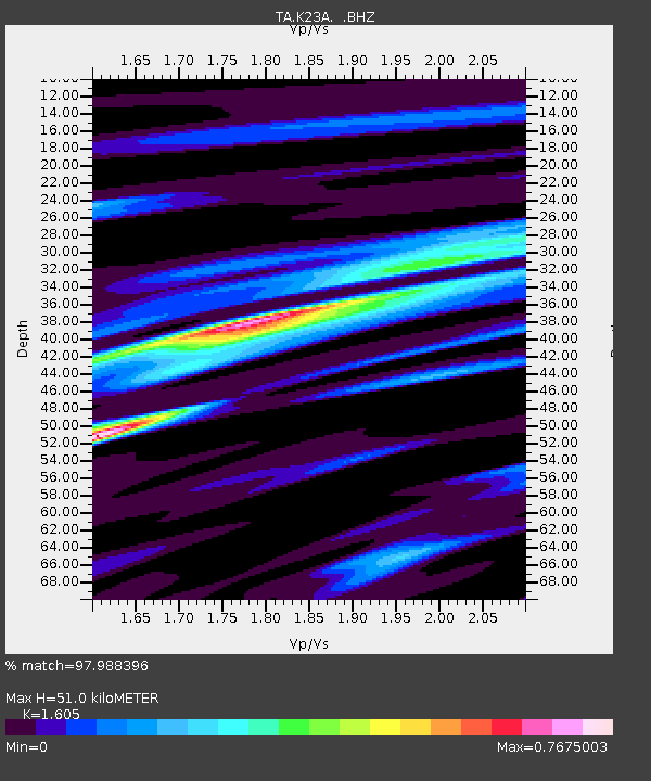
| Estimated Moho Depth: |
51.0 km |
| Estimated Crust Vp/Vs: |
1.61 |
| Assumed Crust Vp: |
6.159 km/s |
| Estimated Crust Vs: |
3.837 km/s |
| Estimated Crust Poisson's Ratio: |
0.18 |
|
| Radial Match: |
97.988396 % |
| Radial Bump: |
274 |
| Transverse Match: |
92.510315 % |
| Transverse Bump: |
400 |
| SOD ConfigId: |
2834 |
| Insert Time: |
2010-03-06 15:22:39.639 +0000 |
| GWidth: |
2.5 |
| Max Bumps: |
400 |
| Tol: |
0.001 |
|
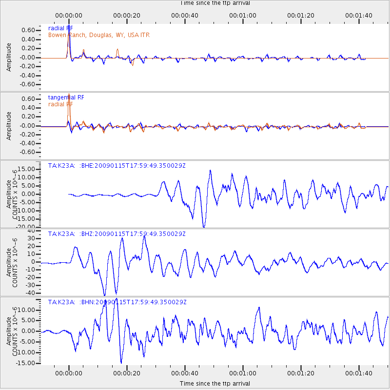
Signal To Noise
| Channel | StoN | STA | LTA |
| TA:K23A: :BHZ:20090115T17:59:49.350029Z | 32.167957 | 1.0955876E-5 | 3.405835E-7 |
| TA:K23A: :BHN:20090115T17:59:49.350029Z | 9.542273 | 3.9488623E-6 | 4.138283E-7 |
| TA:K23A: :BHE:20090115T17:59:49.350029Z | 9.062214 | 4.1869102E-6 | 4.6201845E-7 |
| Arrivals |
| Ps | 5.2 SECOND |
| PpPs | 21 SECOND |
| PsPs/PpSs | 26 SECOND |


