You are here: Home > Network List > CI - Caltech Regional Seismic Network Stations List
> Station SWS Sam W. Stewart, Westmorland, CA, USA > Earthquake Result Viewer
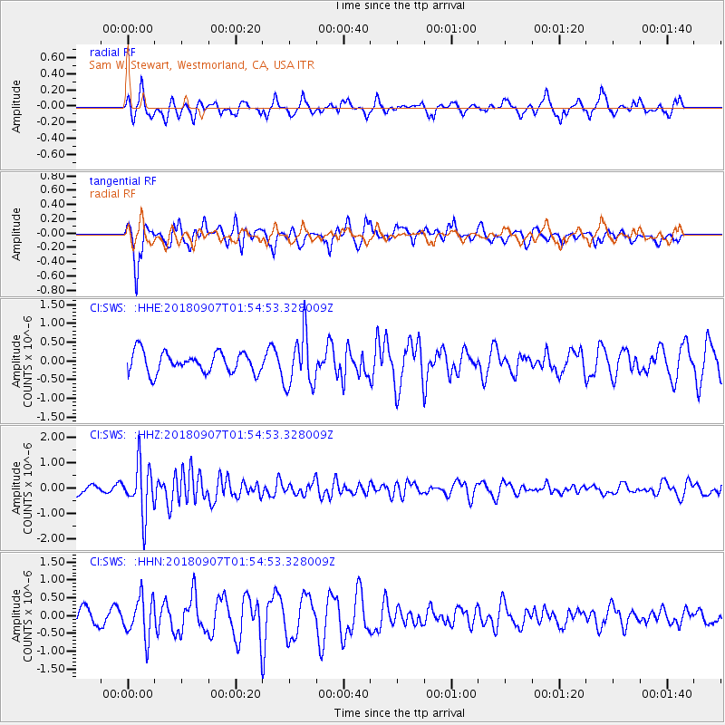
SWS Sam W. Stewart, Westmorland, CA, USA - Earthquake Result Viewer
*The percent match for this event was below the threshold and hence no stack was calculated.
| Earthquake location: |
Panama-Colombia Border Region |
| Earthquake latitude/longitude: |
8.0/-77.6 |
| Earthquake time(UTC): |
2018/09/07 (250) 01:47:23 GMT |
| Earthquake Depth: |
10 km |
| Earthquake Magnitude: |
5.6 mb |
| Earthquake Catalog/Contributor: |
NEIC PDE/us |
|
| Network: |
CI Caltech Regional Seismic Network |
| Station: |
SWS Sam W. Stewart, Westmorland, CA, USA |
| Lat/Lon: |
32.94 N/115.80 W |
| Elevation: |
140 m |
|
| Distance: |
43.1 deg |
| Az: |
310.5 deg |
| Baz: |
116.427 deg |
| Ray Param: |
$rayparam |
*The percent match for this event was below the threshold and hence was not used in the summary stack. |
|
| Radial Match: |
65.34608 % |
| Radial Bump: |
400 |
| Transverse Match: |
85.48103 % |
| Transverse Bump: |
387 |
| SOD ConfigId: |
13570011 |
| Insert Time: |
2019-05-01 03:38:08.828 +0000 |
| GWidth: |
2.5 |
| Max Bumps: |
400 |
| Tol: |
0.001 |
|
Signal To Noise
| Channel | StoN | STA | LTA |
| CI:SWS: :HHZ:20180907T01:54:53.328009Z | 3.1026216 | 1.0092681E-6 | 3.2529525E-7 |
| CI:SWS: :HHN:20180907T01:54:53.328009Z | 1.2465274 | 5.6736025E-7 | 4.5515262E-7 |
| CI:SWS: :HHE:20180907T01:54:53.328009Z | 2.5966902 | 7.120502E-7 | 2.7421456E-7 |
| Arrivals |
| Ps | |
| PpPs | |
| PsPs/PpSs | |


