You are here: Home > Network List > TA - USArray Transportable Network (new EarthScope stations) Stations List
> Station K23A Bowen Ranch, Douglas, WY, USA > Earthquake Result Viewer
K23A Bowen Ranch, Douglas, WY, USA - Earthquake Result Viewer
| Earthquake location: |
Kuril Islands |
| Earthquake latitude/longitude: |
48.3/154.2 |
| Earthquake time(UTC): |
2009/09/10 (253) 02:46:50 GMT |
| Earthquake Depth: |
36 km |
| Earthquake Magnitude: |
6.0 MB, 5.5 MS, 6.0 MW, 5.8 MW |
| Earthquake Catalog/Contributor: |
WHDF/NEIC |
|
| Network: |
TA USArray Transportable Network (new EarthScope stations) |
| Station: |
K23A Bowen Ranch, Douglas, WY, USA |
| Lat/Lon: |
42.75 N/105.63 W |
| Elevation: |
1612 m |
|
| Distance: |
65.4 deg |
| Az: |
52.891 deg |
| Baz: |
313.719 deg |
| Ray Param: |
0.058254663 |
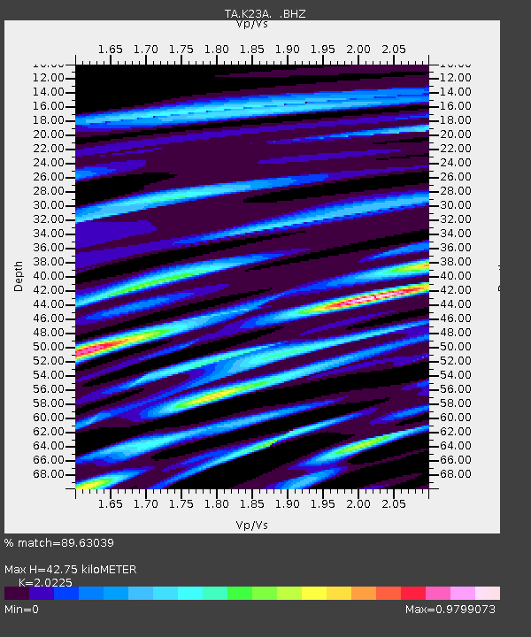
| Estimated Moho Depth: |
42.75 km |
| Estimated Crust Vp/Vs: |
2.02 |
| Assumed Crust Vp: |
6.159 km/s |
| Estimated Crust Vs: |
3.045 km/s |
| Estimated Crust Poisson's Ratio: |
0.34 |
|
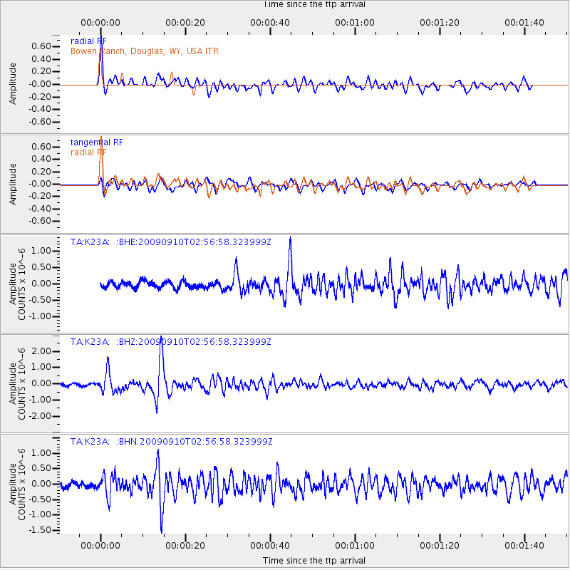
| Radial Match: |
89.63039 % |
| Radial Bump: |
400 |
| Transverse Match: |
77.242874 % |
| Transverse Bump: |
400 |
| SOD ConfigId: |
2622 |
| Insert Time: |
2010-03-06 15:22:49.058 +0000 |
| GWidth: |
2.5 |
| Max Bumps: |
400 |
| Tol: |
0.001 |
|
Signal To Noise
| Channel | StoN | STA | LTA |
| TA:K23A: :BHZ:20090910T02:56:58.323999Z | 6.3715734 | 6.1254207E-7 | 9.61367E-8 |
| TA:K23A: :BHN:20090910T02:56:58.323999Z | 4.009656 | 3.3122905E-7 | 8.260784E-8 |
| TA:K23A: :BHE:20090910T02:56:58.323999Z | 2.919331 | 2.8748238E-7 | 9.8475425E-8 |
| Arrivals |
| Ps | 7.3 SECOND |
| PpPs | 20 SECOND |
| PsPs/PpSs | 28 SECOND |


