You are here: Home > Network List > TA - USArray Transportable Network (new EarthScope stations) Stations List
> Station K23A Bowen Ranch, Douglas, WY, USA > Earthquake Result Viewer
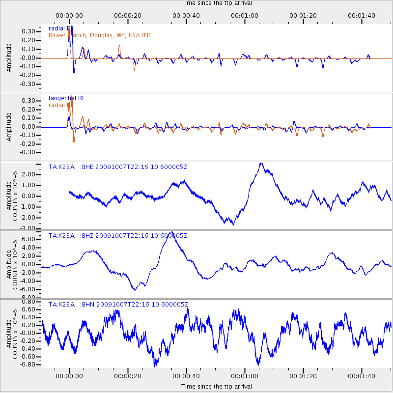
K23A Bowen Ranch, Douglas, WY, USA - Earthquake Result Viewer
| Earthquake location: |
Vanuatu Islands |
| Earthquake latitude/longitude: |
-13.0/166.5 |
| Earthquake time(UTC): |
2009/10/07 (280) 22:03:14 GMT |
| Earthquake Depth: |
45 km |
| Earthquake Magnitude: |
6.4 MB, 7.3 MS, 7.6 MW, 7.7 MW |
| Earthquake Catalog/Contributor: |
WHDF/NEIC |
|
| Network: |
TA USArray Transportable Network (new EarthScope stations) |
| Station: |
K23A Bowen Ranch, Douglas, WY, USA |
| Lat/Lon: |
42.75 N/105.63 W |
| Elevation: |
1612 m |
|
| Distance: |
97.2 deg |
| Az: |
47.885 deg |
| Baz: |
259.003 deg |
| Ray Param: |
0.04027323 |
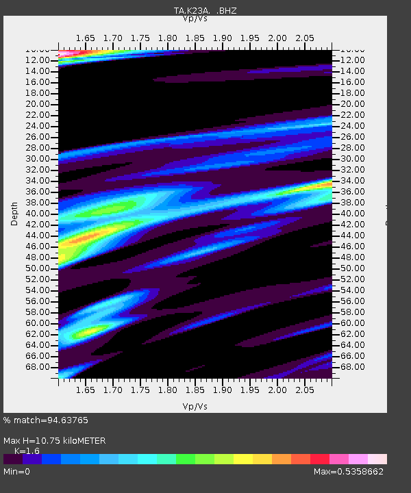
| Estimated Moho Depth: |
10.75 km |
| Estimated Crust Vp/Vs: |
1.60 |
| Assumed Crust Vp: |
6.159 km/s |
| Estimated Crust Vs: |
3.849 km/s |
| Estimated Crust Poisson's Ratio: |
0.18 |
|
| Radial Match: |
94.63765 % |
| Radial Bump: |
400 |
| Transverse Match: |
82.84897 % |
| Transverse Bump: |
400 |
| SOD ConfigId: |
2622 |
| Insert Time: |
2010-03-06 15:22:56.825 +0000 |
| GWidth: |
2.5 |
| Max Bumps: |
400 |
| Tol: |
0.001 |
|
Signal To Noise
| Channel | StoN | STA | LTA |
| TA:K23A: :BHZ:20091007T22:16:10.600005Z | 3.578305 | 1.1160141E-6 | 3.1188344E-7 |
| TA:K23A: :BHN:20091007T22:16:10.600005Z | 1.3323928 | 2.678172E-7 | 2.010047E-7 |
| TA:K23A: :BHE:20091007T22:16:10.600005Z | 1.351156 | 4.320742E-7 | 3.1978112E-7 |
| Arrivals |
| Ps | 1.1 SECOND |
| PpPs | 4.4 SECOND |
| PsPs/PpSs | 5.5 SECOND |


