You are here: Home > Network List > TA - USArray Transportable Network (new EarthScope stations) Stations List
> Station K23A Bowen Ranch, Douglas, WY, USA > Earthquake Result Viewer
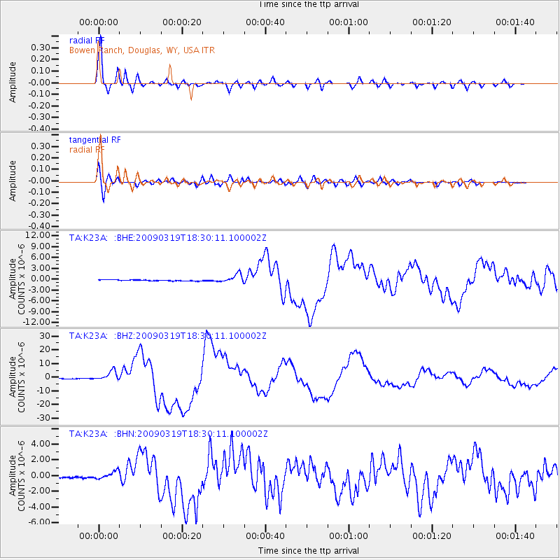
K23A Bowen Ranch, Douglas, WY, USA - Earthquake Result Viewer
| Earthquake location: |
Tonga Islands Region |
| Earthquake latitude/longitude: |
-23.0/-174.7 |
| Earthquake time(UTC): |
2009/03/19 (078) 18:17:40 GMT |
| Earthquake Depth: |
34 km |
| Earthquake Magnitude: |
7.0 MB, 7.6 MS, 7.6 MW, 7.6 MW |
| Earthquake Catalog/Contributor: |
WHDF/NEIC |
|
| Network: |
TA USArray Transportable Network (new EarthScope stations) |
| Station: |
K23A Bowen Ranch, Douglas, WY, USA |
| Lat/Lon: |
42.75 N/105.63 W |
| Elevation: |
1612 m |
|
| Distance: |
91.2 deg |
| Az: |
43.465 deg |
| Baz: |
239.353 deg |
| Ray Param: |
0.041616574 |
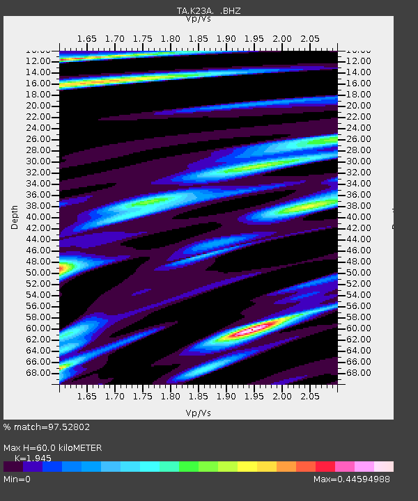
| Estimated Moho Depth: |
60.0 km |
| Estimated Crust Vp/Vs: |
1.95 |
| Assumed Crust Vp: |
6.159 km/s |
| Estimated Crust Vs: |
3.166 km/s |
| Estimated Crust Poisson's Ratio: |
0.32 |
|
| Radial Match: |
97.52802 % |
| Radial Bump: |
400 |
| Transverse Match: |
93.20396 % |
| Transverse Bump: |
400 |
| SOD ConfigId: |
2658 |
| Insert Time: |
2010-03-06 15:23:10.976 +0000 |
| GWidth: |
2.5 |
| Max Bumps: |
400 |
| Tol: |
0.001 |
|
Signal To Noise
| Channel | StoN | STA | LTA |
| TA:K23A: :BHZ:20090319T18:30:11.100002Z | 15.803729 | 3.6634713E-6 | 2.3181056E-7 |
| TA:K23A: :BHN:20090319T18:30:11.100002Z | 7.428251 | 5.406227E-7 | 7.277928E-8 |
| TA:K23A: :BHE:20090319T18:30:11.100002Z | 8.750321 | 1.2345424E-6 | 1.4108538E-7 |
| Arrivals |
| Ps | 9.4 SECOND |
| PpPs | 28 SECOND |
| PsPs/PpSs | 38 SECOND |


