You are here: Home > Network List > TA - USArray Transportable Network (new EarthScope stations) Stations List
> Station K23A Bowen Ranch, Douglas, WY, USA > Earthquake Result Viewer
K23A Bowen Ranch, Douglas, WY, USA - Earthquake Result Viewer
| Earthquake location: |
Kodiak Island Region, Alaska |
| Earthquake latitude/longitude: |
56.5/-152.7 |
| Earthquake time(UTC): |
2009/03/30 (089) 07:13:07 GMT |
| Earthquake Depth: |
21 km |
| Earthquake Magnitude: |
5.9 MB, 5.9 MS, 5.9 MW, 5.9 MW |
| Earthquake Catalog/Contributor: |
WHDF/NEIC |
|
| Network: |
TA USArray Transportable Network (new EarthScope stations) |
| Station: |
K23A Bowen Ranch, Douglas, WY, USA |
| Lat/Lon: |
42.75 N/105.63 W |
| Elevation: |
1612 m |
|
| Distance: |
32.8 deg |
| Az: |
94.523 deg |
| Baz: |
311.443 deg |
| Ray Param: |
0.07848516 |
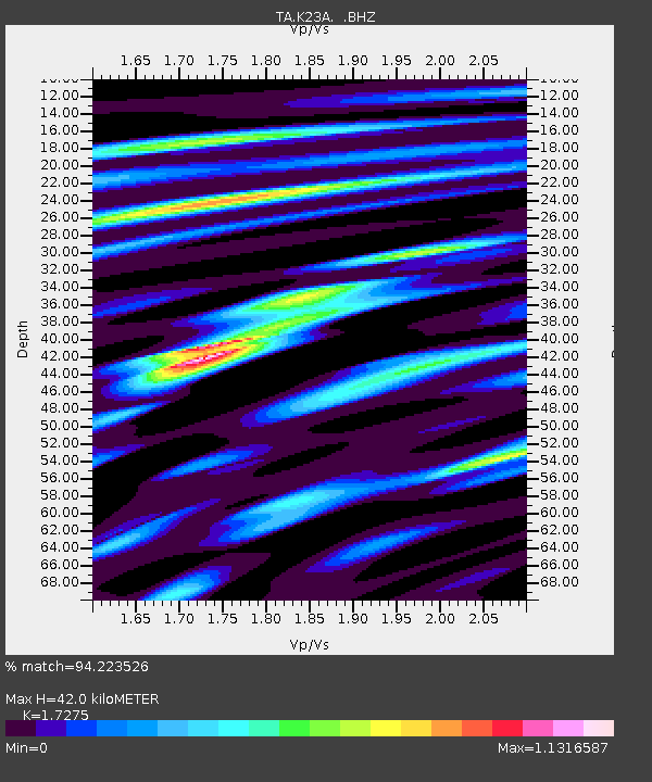
| Estimated Moho Depth: |
42.0 km |
| Estimated Crust Vp/Vs: |
1.73 |
| Assumed Crust Vp: |
6.159 km/s |
| Estimated Crust Vs: |
3.565 km/s |
| Estimated Crust Poisson's Ratio: |
0.25 |
|
| Radial Match: |
94.223526 % |
| Radial Bump: |
333 |
| Transverse Match: |
66.828636 % |
| Transverse Bump: |
400 |
| SOD ConfigId: |
2658 |
| Insert Time: |
2010-03-06 15:23:16.323 +0000 |
| GWidth: |
2.5 |
| Max Bumps: |
400 |
| Tol: |
0.001 |
|
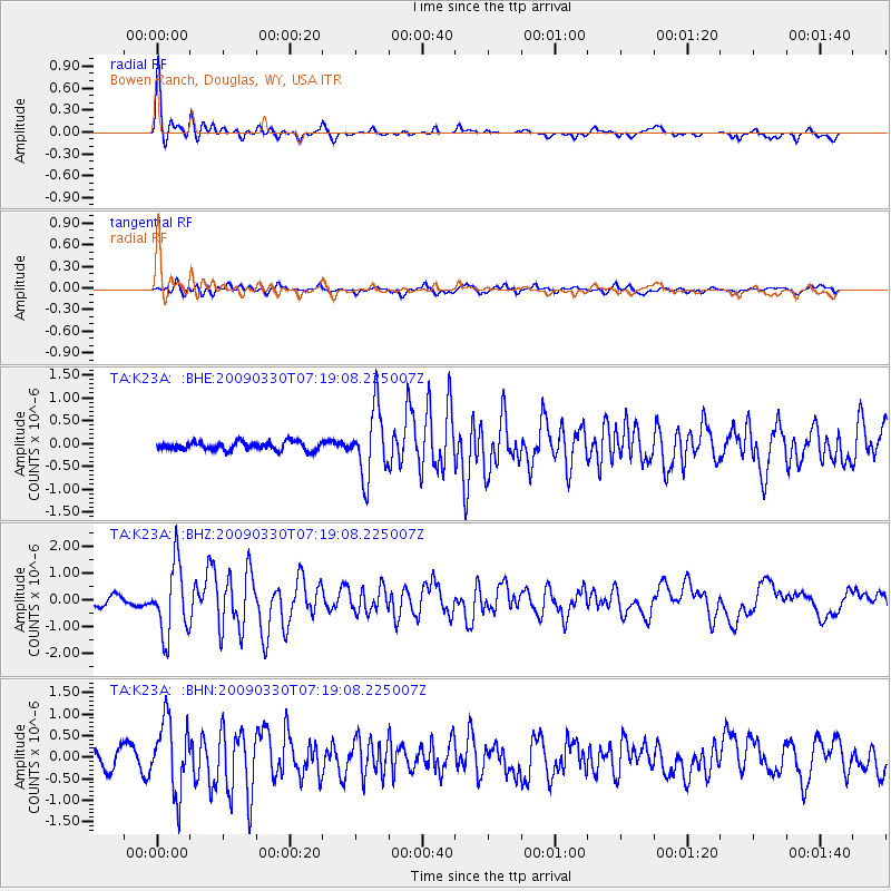
Signal To Noise
| Channel | StoN | STA | LTA |
| TA:K23A: :BHZ:20090330T07:19:08.225007Z | 8.498165 | 1.3073304E-6 | 1.538368E-7 |
| TA:K23A: :BHN:20090330T07:19:08.225007Z | 4.7899966 | 8.2255815E-7 | 1.7172415E-7 |
| TA:K23A: :BHE:20090330T07:19:08.225007Z | 8.103162 | 7.399825E-7 | 9.132022E-8 |
| Arrivals |
| Ps | 5.3 SECOND |
| PpPs | 17 SECOND |
| PsPs/PpSs | 23 SECOND |


