You are here: Home > Network List > TA - USArray Transportable Network (new EarthScope stations) Stations List
> Station O27A Beecher Island, Eckley, CO, USA > Earthquake Result Viewer
O27A Beecher Island, Eckley, CO, USA - Earthquake Result Viewer
| Earthquake location: |
South Of Panama |
| Earthquake latitude/longitude: |
5.7/-82.8 |
| Earthquake time(UTC): |
2009/03/12 (071) 23:23:34 GMT |
| Earthquake Depth: |
9.0 km |
| Earthquake Magnitude: |
6.1 MB, 5.9 MS, 6.3 MW, 6.2 MW |
| Earthquake Catalog/Contributor: |
WHDF/NEIC |
|
| Network: |
TA USArray Transportable Network (new EarthScope stations) |
| Station: |
O27A Beecher Island, Eckley, CO, USA |
| Lat/Lon: |
40.19 N/102.48 W |
| Elevation: |
1206 m |
|
| Distance: |
38.7 deg |
| Az: |
335.566 deg |
| Baz: |
147.496 deg |
| Ray Param: |
0.0754385 |
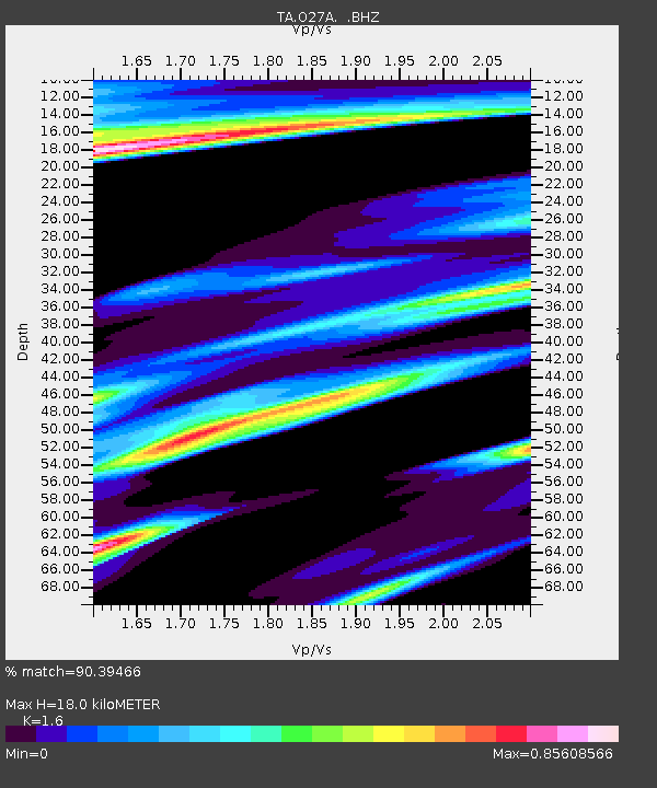
| Estimated Moho Depth: |
18.0 km |
| Estimated Crust Vp/Vs: |
1.60 |
| Assumed Crust Vp: |
6.483 km/s |
| Estimated Crust Vs: |
4.052 km/s |
| Estimated Crust Poisson's Ratio: |
0.18 |
|
| Radial Match: |
90.39466 % |
| Radial Bump: |
332 |
| Transverse Match: |
58.781876 % |
| Transverse Bump: |
400 |
| SOD ConfigId: |
2658 |
| Insert Time: |
2010-03-06 15:24:11.151 +0000 |
| GWidth: |
2.5 |
| Max Bumps: |
400 |
| Tol: |
0.001 |
|
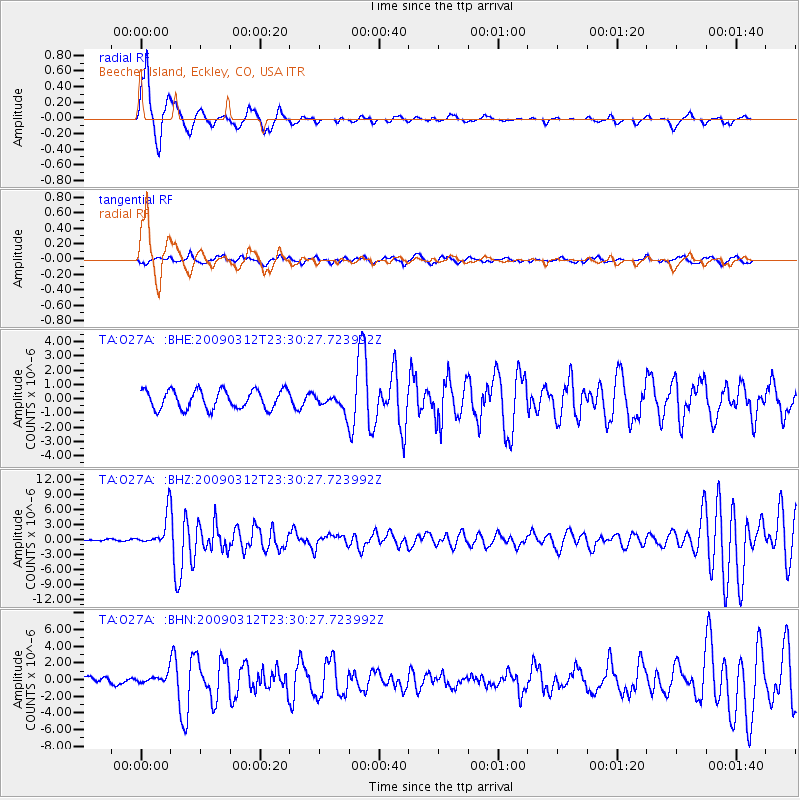
Signal To Noise
| Channel | StoN | STA | LTA |
| TA:O27A: :BHZ:20090312T23:30:27.723992Z | 19.090548 | 3.10417E-6 | 1.6260245E-7 |
| TA:O27A: :BHN:20090312T23:30:27.723992Z | 1.2929695 | 5.2561614E-7 | 4.065186E-7 |
| TA:O27A: :BHE:20090312T23:30:27.723992Z | 0.90362895 | 5.927733E-7 | 6.559919E-7 |
| Arrivals |
| Ps | 1.8 SECOND |
| PpPs | 6.7 SECOND |
| PsPs/PpSs | 8.5 SECOND |


