You are here: Home > Network List > TA - USArray Transportable Network (new EarthScope stations) Stations List
> Station O27A Beecher Island, Eckley, CO, USA > Earthquake Result Viewer
O27A Beecher Island, Eckley, CO, USA - Earthquake Result Viewer
| Earthquake location: |
Panama |
| Earthquake latitude/longitude: |
9.6/-79.0 |
| Earthquake time(UTC): |
2009/07/04 (185) 06:49:35 GMT |
| Earthquake Depth: |
38 km |
| Earthquake Magnitude: |
6.0 MB, 5.5 MS, 6.0 MW, 6.0 MW |
| Earthquake Catalog/Contributor: |
WHDF/NEIC |
|
| Network: |
TA USArray Transportable Network (new EarthScope stations) |
| Station: |
O27A Beecher Island, Eckley, CO, USA |
| Lat/Lon: |
40.19 N/102.48 W |
| Elevation: |
1206 m |
|
| Distance: |
37.0 deg |
| Az: |
329.443 deg |
| Baz: |
139.117 deg |
| Ray Param: |
0.076322086 |
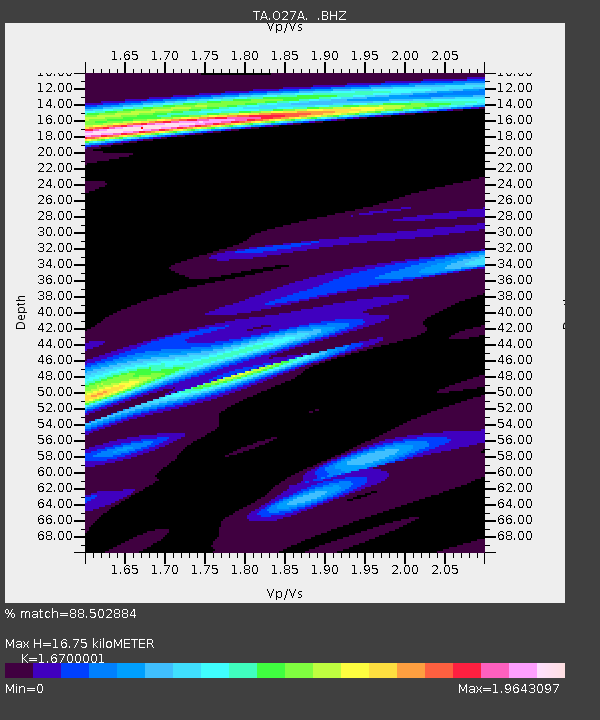
| Estimated Moho Depth: |
16.75 km |
| Estimated Crust Vp/Vs: |
1.67 |
| Assumed Crust Vp: |
6.483 km/s |
| Estimated Crust Vs: |
3.882 km/s |
| Estimated Crust Poisson's Ratio: |
0.22 |
|
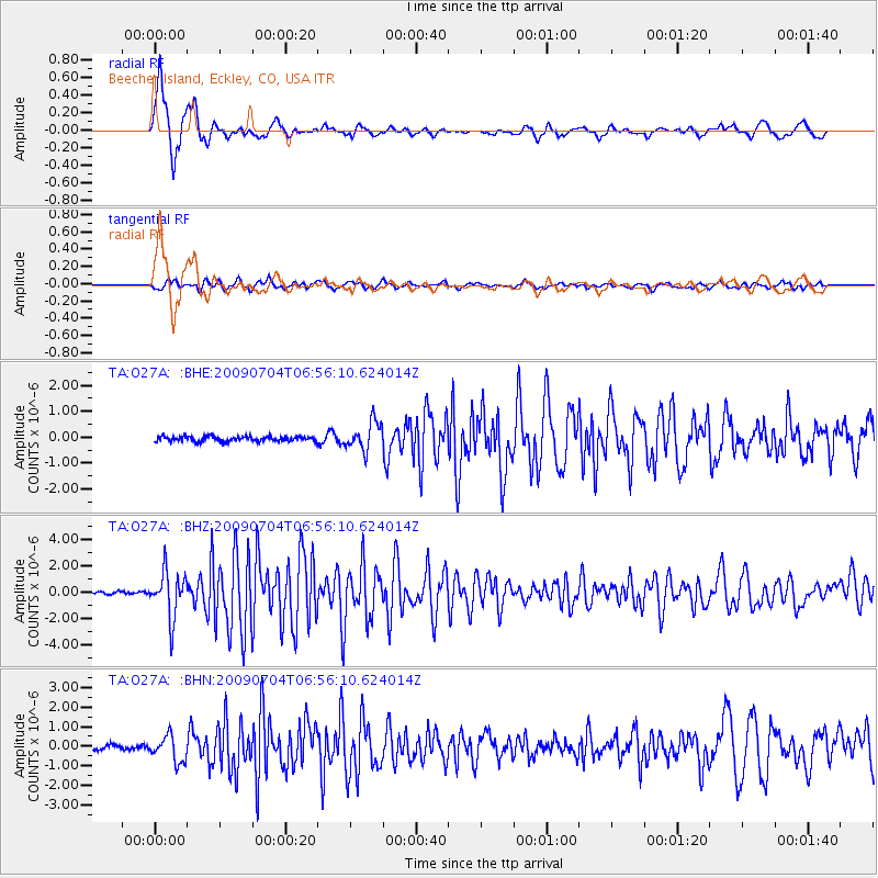
| Radial Match: |
88.502884 % |
| Radial Bump: |
332 |
| Transverse Match: |
78.98587 % |
| Transverse Bump: |
400 |
| SOD ConfigId: |
2648 |
| Insert Time: |
2010-03-06 15:24:17.336 +0000 |
| GWidth: |
2.5 |
| Max Bumps: |
400 |
| Tol: |
0.001 |
|
Signal To Noise
| Channel | StoN | STA | LTA |
| TA:O27A: :BHZ:20090704T06:56:10.624014Z | 17.966314 | 1.7196166E-6 | 9.5713375E-8 |
| TA:O27A: :BHN:20090704T06:56:10.624014Z | 5.8782253 | 6.588004E-7 | 1.120747E-7 |
| TA:O27A: :BHE:20090704T06:56:10.624014Z | 5.6579733 | 5.453185E-7 | 9.638054E-8 |
| Arrivals |
| Ps | 1.9 SECOND |
| PpPs | 6.4 SECOND |
| PsPs/PpSs | 8.2 SECOND |


