You are here: Home > Network List > TA - USArray Transportable Network (new EarthScope stations) Stations List
> Station O27A Beecher Island, Eckley, CO, USA > Earthquake Result Viewer
O27A Beecher Island, Eckley, CO, USA - Earthquake Result Viewer
| Earthquake location: |
Southern Peru |
| Earthquake latitude/longitude: |
-15.0/-70.4 |
| Earthquake time(UTC): |
2009/07/12 (193) 06:12:47 GMT |
| Earthquake Depth: |
199 km |
| Earthquake Magnitude: |
5.7 MB, 6.1 MW, 6.1 MW |
| Earthquake Catalog/Contributor: |
WHDF/NEIC |
|
| Network: |
TA USArray Transportable Network (new EarthScope stations) |
| Station: |
O27A Beecher Island, Eckley, CO, USA |
| Lat/Lon: |
40.19 N/102.48 W |
| Elevation: |
1206 m |
|
| Distance: |
62.5 deg |
| Az: |
332.738 deg |
| Baz: |
144.708 deg |
| Ray Param: |
0.059572943 |
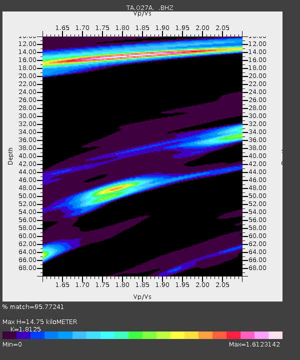
| Estimated Moho Depth: |
14.75 km |
| Estimated Crust Vp/Vs: |
1.81 |
| Assumed Crust Vp: |
6.483 km/s |
| Estimated Crust Vs: |
3.577 km/s |
| Estimated Crust Poisson's Ratio: |
0.28 |
|
| Radial Match: |
95.77241 % |
| Radial Bump: |
300 |
| Transverse Match: |
75.2409 % |
| Transverse Bump: |
400 |
| SOD ConfigId: |
2648 |
| Insert Time: |
2010-03-06 15:24:26.004 +0000 |
| GWidth: |
2.5 |
| Max Bumps: |
400 |
| Tol: |
0.001 |
|
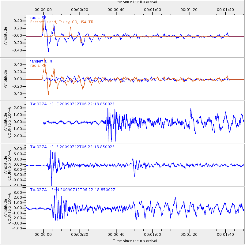
Signal To Noise
| Channel | StoN | STA | LTA |
| TA:O27A: :BHZ:20090712T06:22:18.85002Z | 34.185818 | 3.1292284E-6 | 9.153587E-8 |
| TA:O27A: :BHN:20090712T06:22:18.85002Z | 1.8469104 | 2.219325E-7 | 1.2016419E-7 |
| TA:O27A: :BHE:20090712T06:22:18.85002Z | 2.6629317 | 2.8452288E-7 | 1.0684573E-7 |
| Arrivals |
| Ps | 1.9 SECOND |
| PpPs | 6.1 SECOND |
| PsPs/PpSs | 8.1 SECOND |


