You are here: Home > Network List > TA - USArray Transportable Network (new EarthScope stations) Stations List
> Station O27A Beecher Island, Eckley, CO, USA > Earthquake Result Viewer
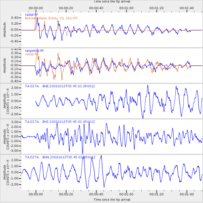
O27A Beecher Island, Eckley, CO, USA - Earthquake Result Viewer
*The percent match for this event was below the threshold and hence no stack was calculated.
| Earthquake location: |
Fox Islands, Aleutian Islands |
| Earthquake latitude/longitude: |
52.8/-167.0 |
| Earthquake time(UTC): |
2009/10/13 (286) 05:37:23 GMT |
| Earthquake Depth: |
24 km |
| Earthquake Magnitude: |
6.0 MB, 6.1 MS, 6.5 MW, 6.5 MW |
| Earthquake Catalog/Contributor: |
WHDF/NEIC |
|
| Network: |
TA USArray Transportable Network (new EarthScope stations) |
| Station: |
O27A Beecher Island, Eckley, CO, USA |
| Lat/Lon: |
40.19 N/102.48 W |
| Elevation: |
1206 m |
|
| Distance: |
44.7 deg |
| Az: |
79.434 deg |
| Baz: |
308.74 deg |
| Ray Param: |
$rayparam |
*The percent match for this event was below the threshold and hence was not used in the summary stack. |
|
| Radial Match: |
72.33988 % |
| Radial Bump: |
392 |
| Transverse Match: |
37.46364 % |
| Transverse Bump: |
342 |
| SOD ConfigId: |
2622 |
| Insert Time: |
2010-03-06 15:24:50.767 +0000 |
| GWidth: |
2.5 |
| Max Bumps: |
400 |
| Tol: |
0.001 |
|
Signal To Noise
| Channel | StoN | STA | LTA |
| TA:O27A: :BHZ:20091013T05:45:03.95001Z | 2.5607276 | 4.9699804E-7 | 1.9408469E-7 |
| TA:O27A: :BHN:20091013T05:45:03.95001Z | 2.3008065 | 9.861359E-7 | 4.2860444E-7 |
| TA:O27A: :BHE:20091013T05:45:03.95001Z | 1.1186702 | 5.3980386E-7 | 4.8254066E-7 |
| Arrivals |
| Ps | |
| PpPs | |
| PsPs/PpSs | |


