You are here: Home > Network List > TA - USArray Transportable Network (new EarthScope stations) Stations List
> Station O27A Beecher Island, Eckley, CO, USA > Earthquake Result Viewer
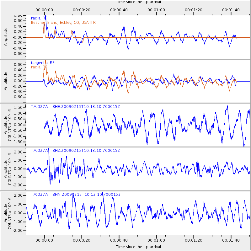
O27A Beecher Island, Eckley, CO, USA - Earthquake Result Viewer
*The percent match for this event was below the threshold and hence no stack was calculated.
| Earthquake location: |
Near Coast Of Northern Peru |
| Earthquake latitude/longitude: |
-5.9/-80.9 |
| Earthquake time(UTC): |
2009/02/15 (046) 10:04:49 GMT |
| Earthquake Depth: |
21 km |
| Earthquake Magnitude: |
5.8 MB, 5.7 MS, 6.1 MW, 6.1 MW |
| Earthquake Catalog/Contributor: |
WHDF/NEIC |
|
| Network: |
TA USArray Transportable Network (new EarthScope stations) |
| Station: |
O27A Beecher Island, Eckley, CO, USA |
| Lat/Lon: |
40.19 N/102.48 W |
| Elevation: |
1206 m |
|
| Distance: |
49.9 deg |
| Az: |
338.394 deg |
| Baz: |
151.431 deg |
| Ray Param: |
$rayparam |
*The percent match for this event was below the threshold and hence was not used in the summary stack. |
|
| Radial Match: |
45.427147 % |
| Radial Bump: |
367 |
| Transverse Match: |
61.221043 % |
| Transverse Bump: |
390 |
| SOD ConfigId: |
2658 |
| Insert Time: |
2010-03-06 15:25:23.562 +0000 |
| GWidth: |
2.5 |
| Max Bumps: |
400 |
| Tol: |
0.001 |
|
Signal To Noise
| Channel | StoN | STA | LTA |
| TA:O27A: :BHZ:20090215T10:13:10.700015Z | 3.0933735 | 1.006197E-6 | 3.2527495E-7 |
| TA:O27A: :BHN:20090215T10:13:10.700015Z | 0.5455073 | 5.0688215E-7 | 9.2919413E-7 |
| TA:O27A: :BHE:20090215T10:13:10.700015Z | 0.5492436 | 3.447676E-7 | 6.2771346E-7 |
| Arrivals |
| Ps | |
| PpPs | |
| PsPs/PpSs | |


