You are here: Home > Network List > AK - Alaska Regional Network Stations List
> Station NICH Nichawak Mountain, AK, USA > Earthquake Result Viewer
NICH Nichawak Mountain, AK, USA - Earthquake Result Viewer
| Earthquake location: |
Ecuador |
| Earthquake latitude/longitude: |
-2.3/-78.9 |
| Earthquake time(UTC): |
2018/09/07 (250) 02:12:04 GMT |
| Earthquake Depth: |
94 km |
| Earthquake Magnitude: |
6.2 Mww |
| Earthquake Catalog/Contributor: |
NEIC PDE/us |
|
| Network: |
AK Alaska Regional Network |
| Station: |
NICH Nichawak Mountain, AK, USA |
| Lat/Lon: |
60.24 N/143.97 W |
| Elevation: |
507 m |
|
| Distance: |
79.9 deg |
| Az: |
332.642 deg |
| Baz: |
113.033 deg |
| Ray Param: |
0.04842032 |
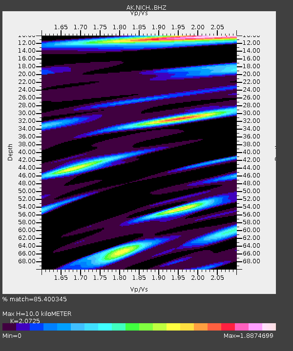
| Estimated Moho Depth: |
10.0 km |
| Estimated Crust Vp/Vs: |
2.07 |
| Assumed Crust Vp: |
6.566 km/s |
| Estimated Crust Vs: |
3.168 km/s |
| Estimated Crust Poisson's Ratio: |
0.35 |
|
| Radial Match: |
85.400345 % |
| Radial Bump: |
393 |
| Transverse Match: |
87.54776 % |
| Transverse Bump: |
400 |
| SOD ConfigId: |
13570011 |
| Insert Time: |
2019-05-01 03:49:20.293 +0000 |
| GWidth: |
2.5 |
| Max Bumps: |
400 |
| Tol: |
0.001 |
|

Signal To Noise
| Channel | StoN | STA | LTA |
| AK:NICH: :BHZ:20180907T02:23:32.00802Z | 31.416224 | 3.931308E-6 | 1.2513625E-7 |
| AK:NICH: :BHN:20180907T02:23:32.00802Z | 6.7296243 | 7.665081E-7 | 1.1390058E-7 |
| AK:NICH: :BHE:20180907T02:23:32.00802Z | 10.7415695 | 1.5170376E-6 | 1.4123054E-7 |
| Arrivals |
| Ps | 1.7 SECOND |
| PpPs | 4.6 SECOND |
| PsPs/PpSs | 6.2 SECOND |


