You are here: Home > Network List > TA - USArray Transportable Network (new EarthScope stations) Stations List
> Station N26A Koester Ranch, Padroni, CO, USA > Earthquake Result Viewer
N26A Koester Ranch, Padroni, CO, USA - Earthquake Result Viewer
| Earthquake location: |
Costa Rica |
| Earthquake latitude/longitude: |
10.2/-84.2 |
| Earthquake time(UTC): |
2009/01/08 (008) 19:21:35 GMT |
| Earthquake Depth: |
14 km |
| Earthquake Magnitude: |
5.7 MB, 6.0 MS, 6.1 MW, 6.1 MW |
| Earthquake Catalog/Contributor: |
WHDF/NEIC |
|
| Network: |
TA USArray Transportable Network (new EarthScope stations) |
| Station: |
N26A Koester Ranch, Padroni, CO, USA |
| Lat/Lon: |
40.83 N/103.22 W |
| Elevation: |
1284 m |
|
| Distance: |
34.9 deg |
| Az: |
334.362 deg |
| Baz: |
145.85 deg |
| Ray Param: |
0.077509575 |
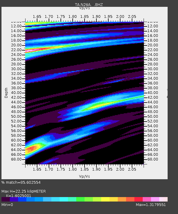
| Estimated Moho Depth: |
22.25 km |
| Estimated Crust Vp/Vs: |
1.60 |
| Assumed Crust Vp: |
6.483 km/s |
| Estimated Crust Vs: |
4.045 km/s |
| Estimated Crust Poisson's Ratio: |
0.18 |
|
| Radial Match: |
85.602554 % |
| Radial Bump: |
266 |
| Transverse Match: |
67.197014 % |
| Transverse Bump: |
332 |
| SOD ConfigId: |
2834 |
| Insert Time: |
2010-03-06 15:25:26.410 +0000 |
| GWidth: |
2.5 |
| Max Bumps: |
400 |
| Tol: |
0.001 |
|

Signal To Noise
| Channel | StoN | STA | LTA |
| TA:N26A: :BHZ:20090108T19:27:55.550002Z | 3.569397 | 1.1074022E-6 | 3.102491E-7 |
| TA:N26A: :BHN:20090108T19:27:55.550002Z | 1.0809734 | 7.164075E-7 | 6.6274293E-7 |
| TA:N26A: :BHE:20090108T19:27:55.550002Z | 0.91031563 | 6.9951284E-7 | 7.684289E-7 |
| Arrivals |
| Ps | 2.3 SECOND |
| PpPs | 8.2 SECOND |
| PsPs/PpSs | 10 SECOND |


