You are here: Home > Network List > TA - USArray Transportable Network (new EarthScope stations) Stations List
> Station N26A Koester Ranch, Padroni, CO, USA > Earthquake Result Viewer
N26A Koester Ranch, Padroni, CO, USA - Earthquake Result Viewer

| Earthquake location: |
Off Coast Of Costa Rica |
| Earthquake latitude/longitude: |
7.9/-85.6 |
| Earthquake time(UTC): |
2009/08/13 (225) 09:37:35 GMT |
| Earthquake Depth: |
10 km |
| Earthquake Magnitude: |
5.8 MW, 5.3 MB |
| Earthquake Catalog/Contributor: |
WHDF/NEIC |
|
| Network: |
TA USArray Transportable Network (new EarthScope stations) |
| Station: |
N26A Koester Ranch, Padroni, CO, USA |
| Lat/Lon: |
40.83 N/103.22 W |
| Elevation: |
1284 m |
|
| Distance: |
36.3 deg |
| Az: |
337.209 deg |
| Baz: |
149.626 deg |
| Ray Param: |
0.076757655 |
| Estimated Moho Depth: |
22.5 km |
| Estimated Crust Vp/Vs: |
1.60 |
| Assumed Crust Vp: |
6.483 km/s |
| Estimated Crust Vs: |
4.052 km/s |
| Estimated Crust Poisson's Ratio: |
0.18 |
|
| Radial Match: |
86.00519 % |
| Radial Bump: |
325 |
| Transverse Match: |
41.51599 % |
| Transverse Bump: |
332 |
| SOD ConfigId: |
2622 |
| Insert Time: |
2010-03-06 15:25:33.960 +0000 |
| GWidth: |
2.5 |
| Max Bumps: |
400 |
| Tol: |
0.001 |
|
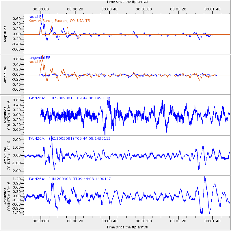
Signal To Noise
| Channel | StoN | STA | LTA |
| TA:N26A: :BHZ:20090813T09:44:08.149011Z | 8.503303 | 5.6161366E-7 | 6.604653E-8 |
| TA:N26A: :BHN:20090813T09:44:08.149011Z | 2.258318 | 2.2013998E-7 | 9.747962E-8 |
| TA:N26A: :BHE:20090813T09:44:08.149011Z | 0.9828053 | 1.4456496E-7 | 1.470942E-7 |
| Arrivals |
| Ps | 2.3 SECOND |
| PpPs | 8.3 SECOND |
| PsPs/PpSs | 11 SECOND |


