You are here: Home > Network List > TA - USArray Transportable Network (new EarthScope stations) Stations List
> Station N26A Koester Ranch, Padroni, CO, USA > Earthquake Result Viewer
N26A Koester Ranch, Padroni, CO, USA - Earthquake Result Viewer

| Earthquake location: |
Norwegian Sea |
| Earthquake latitude/longitude: |
72.2/0.9 |
| Earthquake time(UTC): |
2009/08/20 (232) 06:35:04 GMT |
| Earthquake Depth: |
6.0 km |
| Earthquake Magnitude: |
5.9 MB, 5.7 MS, 6.0 MW, 6.0 MW |
| Earthquake Catalog/Contributor: |
WHDF/NEIC |
|
| Network: |
TA USArray Transportable Network (new EarthScope stations) |
| Station: |
N26A Koester Ranch, Padroni, CO, USA |
| Lat/Lon: |
40.83 N/103.22 W |
| Elevation: |
1284 m |
|
| Distance: |
55.8 deg |
| Az: |
297.132 deg |
| Baz: |
21.144 deg |
| Ray Param: |
0.064590216 |
| Estimated Moho Depth: |
18.0 km |
| Estimated Crust Vp/Vs: |
1.74 |
| Assumed Crust Vp: |
6.483 km/s |
| Estimated Crust Vs: |
3.736 km/s |
| Estimated Crust Poisson's Ratio: |
0.25 |
|
| Radial Match: |
85.75252 % |
| Radial Bump: |
400 |
| Transverse Match: |
61.7363 % |
| Transverse Bump: |
400 |
| SOD ConfigId: |
2622 |
| Insert Time: |
2010-03-06 15:25:36.849 +0000 |
| GWidth: |
2.5 |
| Max Bumps: |
400 |
| Tol: |
0.001 |
|
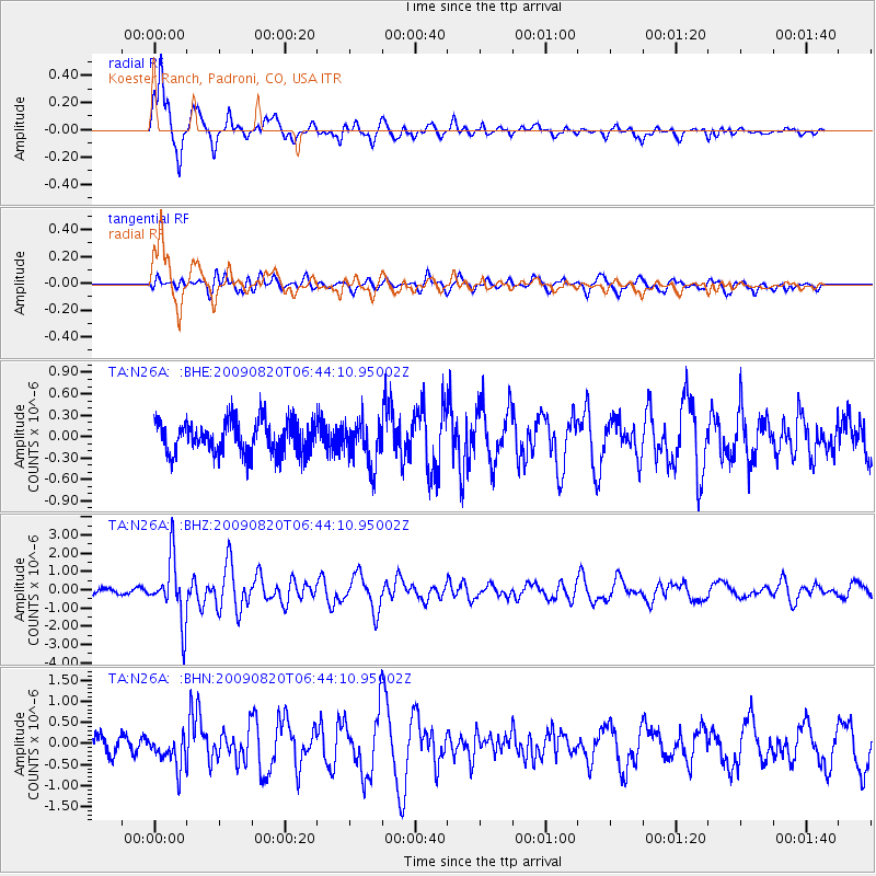
Signal To Noise
| Channel | StoN | STA | LTA |
| TA:N26A: :BHZ:20090820T06:44:10.95002Z | 11.265564 | 1.6867263E-6 | 1.4972409E-7 |
| TA:N26A: :BHN:20090820T06:44:10.95002Z | 2.2472405 | 3.815426E-7 | 1.6978271E-7 |
| TA:N26A: :BHE:20090820T06:44:10.95002Z | 1.325333 | 3.0424692E-7 | 2.2956263E-7 |
| Arrivals |
| Ps | 2.2 SECOND |
| PpPs | 7.2 SECOND |
| PsPs/PpSs | 9.4 SECOND |


