You are here: Home > Network List > TA - USArray Transportable Network (new EarthScope stations) Stations List
> Station N26A Koester Ranch, Padroni, CO, USA > Earthquake Result Viewer
N26A Koester Ranch, Padroni, CO, USA - Earthquake Result Viewer
| Earthquake location: |
Near Coast Of Venezuela |
| Earthquake latitude/longitude: |
10.7/-67.9 |
| Earthquake time(UTC): |
2009/09/12 (255) 20:06:24 GMT |
| Earthquake Depth: |
10 km |
| Earthquake Magnitude: |
6.3 MB, 6.4 MS, 6.3 MW, 6.3 MW |
| Earthquake Catalog/Contributor: |
WHDF/NEIC |
|
| Network: |
TA USArray Transportable Network (new EarthScope stations) |
| Station: |
N26A Koester Ranch, Padroni, CO, USA |
| Lat/Lon: |
40.83 N/103.22 W |
| Elevation: |
1284 m |
|
| Distance: |
43.2 deg |
| Az: |
320.172 deg |
| Baz: |
123.948 deg |
| Ray Param: |
0.07269928 |
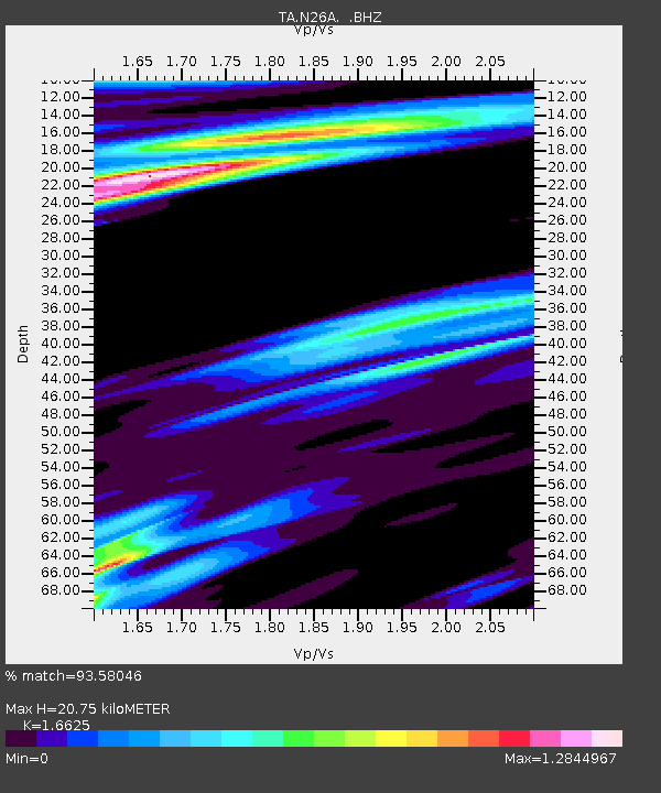
| Estimated Moho Depth: |
20.75 km |
| Estimated Crust Vp/Vs: |
1.66 |
| Assumed Crust Vp: |
6.483 km/s |
| Estimated Crust Vs: |
3.899 km/s |
| Estimated Crust Poisson's Ratio: |
0.22 |
|
| Radial Match: |
93.58046 % |
| Radial Bump: |
314 |
| Transverse Match: |
75.65221 % |
| Transverse Bump: |
400 |
| SOD ConfigId: |
2622 |
| Insert Time: |
2010-03-06 15:25:40.684 +0000 |
| GWidth: |
2.5 |
| Max Bumps: |
400 |
| Tol: |
0.001 |
|

Signal To Noise
| Channel | StoN | STA | LTA |
| TA:N26A: :BHZ:20090912T20:13:54.900011Z | 9.603096 | 1.9996173E-6 | 2.0822633E-7 |
| TA:N26A: :BHN:20090912T20:13:54.900011Z | 2.5161738 | 7.3346536E-7 | 2.9150027E-7 |
| TA:N26A: :BHE:20090912T20:13:54.900011Z | 1.4214983 | 4.9318885E-7 | 3.4695E-7 |
| Arrivals |
| Ps | 2.3 SECOND |
| PpPs | 7.9 SECOND |
| PsPs/PpSs | 10 SECOND |


