You are here: Home > Network List > TA - USArray Transportable Network (new EarthScope stations) Stations List
> Station N26A Koester Ranch, Padroni, CO, USA > Earthquake Result Viewer
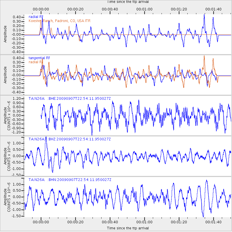
N26A Koester Ranch, Padroni, CO, USA - Earthquake Result Viewer
*The percent match for this event was below the threshold and hence no stack was calculated.
| Earthquake location: |
Northwestern Caucasus |
| Earthquake latitude/longitude: |
42.7/43.4 |
| Earthquake time(UTC): |
2009/09/07 (250) 22:41:37 GMT |
| Earthquake Depth: |
15 km |
| Earthquake Magnitude: |
5.7 MB, 5.8 MS, 6.0 MW, 5.9 MW |
| Earthquake Catalog/Contributor: |
WHDF/NEIC |
|
| Network: |
TA USArray Transportable Network (new EarthScope stations) |
| Station: |
N26A Koester Ranch, Padroni, CO, USA |
| Lat/Lon: |
40.83 N/103.22 W |
| Elevation: |
1284 m |
|
| Distance: |
91.6 deg |
| Az: |
335.344 deg |
| Baz: |
23.924 deg |
| Ray Param: |
$rayparam |
*The percent match for this event was below the threshold and hence was not used in the summary stack. |
|
| Radial Match: |
62.73003 % |
| Radial Bump: |
387 |
| Transverse Match: |
59.6657 % |
| Transverse Bump: |
347 |
| SOD ConfigId: |
2622 |
| Insert Time: |
2010-03-06 15:26:18.772 +0000 |
| GWidth: |
2.5 |
| Max Bumps: |
400 |
| Tol: |
0.001 |
|
Signal To Noise
| Channel | StoN | STA | LTA |
| TA:N26A: :BHZ:20090907T22:54:11.950027Z | 3.207026 | 6.9584047E-7 | 2.1697375E-7 |
| TA:N26A: :BHN:20090907T22:54:11.950027Z | 0.62502825 | 3.614361E-7 | 5.782716E-7 |
| TA:N26A: :BHE:20090907T22:54:11.950027Z | 1.2224654 | 5.8495823E-7 | 4.78507E-7 |
| Arrivals |
| Ps | |
| PpPs | |
| PsPs/PpSs | |


