You are here: Home > Network List > TA - USArray Transportable Network (new EarthScope stations) Stations List
> Station N26A Koester Ranch, Padroni, CO, USA > Earthquake Result Viewer
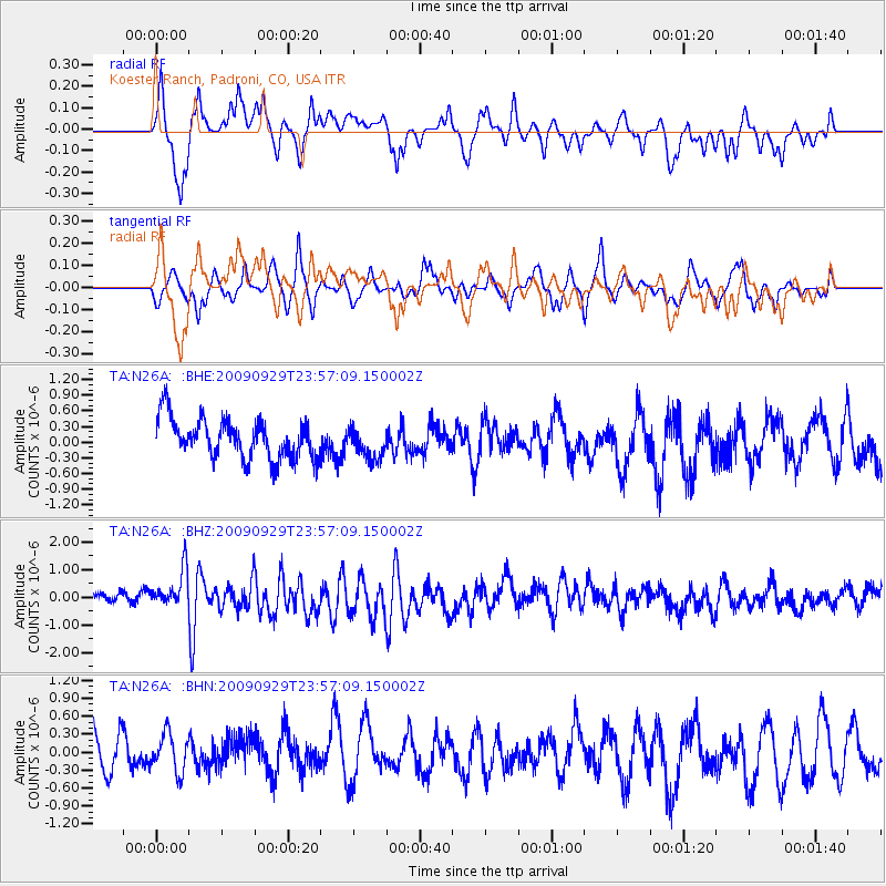
N26A Koester Ranch, Padroni, CO, USA - Earthquake Result Viewer
*The percent match for this event was below the threshold and hence no stack was calculated.
| Earthquake location: |
Samoa Islands Region |
| Earthquake latitude/longitude: |
-15.8/-172.6 |
| Earthquake time(UTC): |
2009/09/29 (272) 23:45:03 GMT |
| Earthquake Depth: |
10 km |
| Earthquake Magnitude: |
6.0 MB, 5.8 MS |
| Earthquake Catalog/Contributor: |
WHDF/NEIC |
|
| Network: |
TA USArray Transportable Network (new EarthScope stations) |
| Station: |
N26A Koester Ranch, Padroni, CO, USA |
| Lat/Lon: |
40.83 N/103.22 W |
| Elevation: |
1284 m |
|
| Distance: |
85.3 deg |
| Az: |
45.425 deg |
| Baz: |
244.631 deg |
| Ray Param: |
$rayparam |
*The percent match for this event was below the threshold and hence was not used in the summary stack. |
|
| Radial Match: |
52.55138 % |
| Radial Bump: |
338 |
| Transverse Match: |
53.7698 % |
| Transverse Bump: |
338 |
| SOD ConfigId: |
2622 |
| Insert Time: |
2010-03-06 15:26:21.940 +0000 |
| GWidth: |
2.5 |
| Max Bumps: |
400 |
| Tol: |
0.001 |
|
Signal To Noise
| Channel | StoN | STA | LTA |
| TA:N26A: :BHZ:20090929T23:57:09.150002Z | 3.699214 | 7.2302555E-7 | 1.9545384E-7 |
| TA:N26A: :BHN:20090929T23:57:09.150002Z | 1.0628662 | 3.206526E-7 | 3.0168667E-7 |
| TA:N26A: :BHE:20090929T23:57:09.150002Z | 0.78083736 | 2.987202E-7 | 3.825639E-7 |
| Arrivals |
| Ps | |
| PpPs | |
| PsPs/PpSs | |


