You are here: Home > Network List > TA - USArray Transportable Network (new EarthScope stations) Stations List
> Station N26A Koester Ranch, Padroni, CO, USA > Earthquake Result Viewer
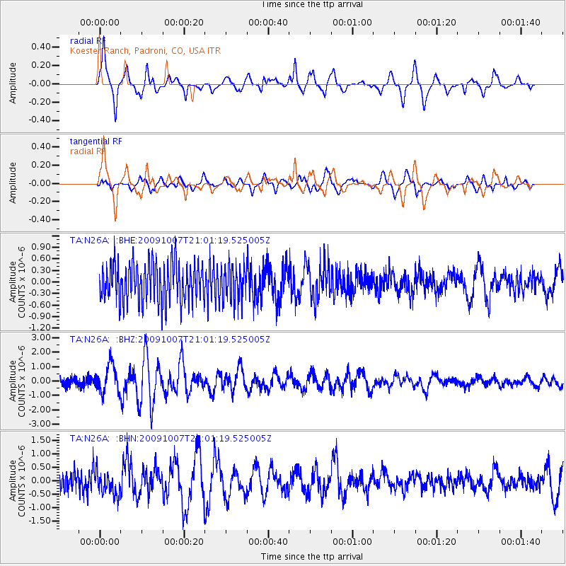
N26A Koester Ranch, Padroni, CO, USA - Earthquake Result Viewer
*The percent match for this event was below the threshold and hence no stack was calculated.
| Earthquake location: |
East Of Severnaya Zemlya |
| Earthquake latitude/longitude: |
81.6/119.5 |
| Earthquake time(UTC): |
2009/10/07 (280) 20:52:13 GMT |
| Earthquake Depth: |
8.0 km |
| Earthquake Magnitude: |
5.7 MB, 5.1 MS, 5.8 MW, 5.8 MW |
| Earthquake Catalog/Contributor: |
WHDF/NEIC |
|
| Network: |
TA USArray Transportable Network (new EarthScope stations) |
| Station: |
N26A Koester Ranch, Padroni, CO, USA |
| Lat/Lon: |
40.83 N/103.22 W |
| Elevation: |
1284 m |
|
| Distance: |
55.8 deg |
| Az: |
38.52 deg |
| Baz: |
353.045 deg |
| Ray Param: |
$rayparam |
*The percent match for this event was below the threshold and hence was not used in the summary stack. |
|
| Radial Match: |
74.03715 % |
| Radial Bump: |
368 |
| Transverse Match: |
59.240303 % |
| Transverse Bump: |
386 |
| SOD ConfigId: |
2622 |
| Insert Time: |
2010-03-06 15:26:28.008 +0000 |
| GWidth: |
2.5 |
| Max Bumps: |
400 |
| Tol: |
0.001 |
|
Signal To Noise
| Channel | StoN | STA | LTA |
| TA:N26A: :BHZ:20091007T21:01:19.525005Z | 3.0496037 | 1.0068816E-6 | 3.30168E-7 |
| TA:N26A: :BHN:20091007T21:01:19.525005Z | 1.0684668 | 4.3043548E-7 | 4.028534E-7 |
| TA:N26A: :BHE:20091007T21:01:19.525005Z | 0.8669439 | 4.364351E-7 | 5.0341794E-7 |
| Arrivals |
| Ps | |
| PpPs | |
| PsPs/PpSs | |


