You are here: Home > Network List > TA - USArray Transportable Network (new EarthScope stations) Stations List
> Station N26A Koester Ranch, Padroni, CO, USA > Earthquake Result Viewer
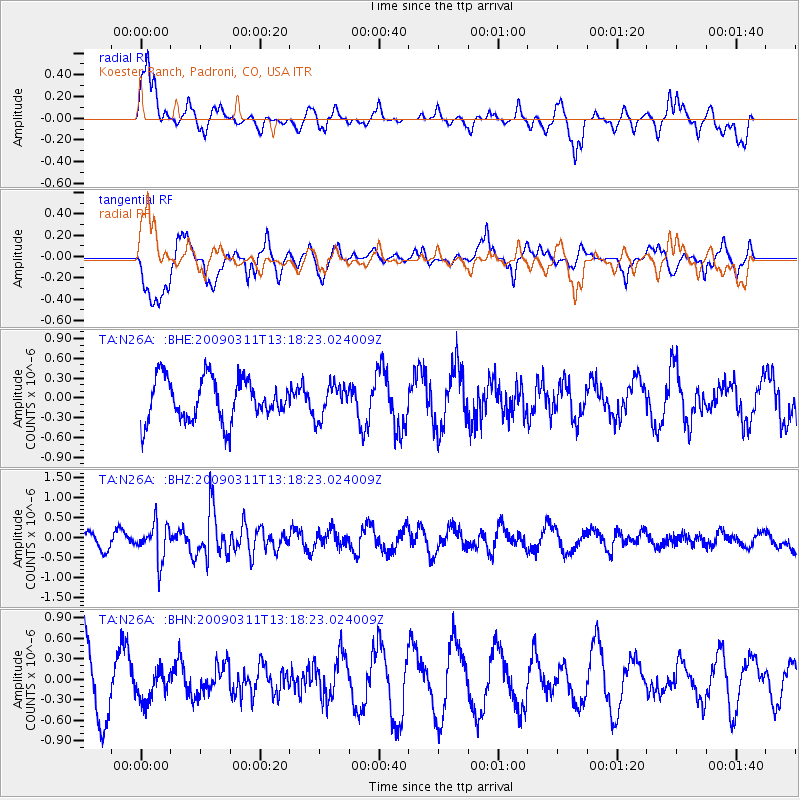
N26A Koester Ranch, Padroni, CO, USA - Earthquake Result Viewer
*The percent match for this event was below the threshold and hence no stack was calculated.
| Earthquake location: |
San Juan Province, Argentina |
| Earthquake latitude/longitude: |
-31.9/-69.2 |
| Earthquake time(UTC): |
2009/03/11 (070) 13:06:53 GMT |
| Earthquake Depth: |
28 km |
| Earthquake Magnitude: |
5.5 MB, 4.8 MS, 5.3 MW, 5.5 ML |
| Earthquake Catalog/Contributor: |
WHDF/NEIC |
|
| Network: |
TA USArray Transportable Network (new EarthScope stations) |
| Station: |
N26A Koester Ranch, Padroni, CO, USA |
| Lat/Lon: |
40.83 N/103.22 W |
| Elevation: |
1284 m |
|
| Distance: |
78.9 deg |
| Az: |
334.355 deg |
| Baz: |
150.975 deg |
| Ray Param: |
$rayparam |
*The percent match for this event was below the threshold and hence was not used in the summary stack. |
|
| Radial Match: |
71.45148 % |
| Radial Bump: |
376 |
| Transverse Match: |
63.013035 % |
| Transverse Bump: |
396 |
| SOD ConfigId: |
2658 |
| Insert Time: |
2010-03-06 15:26:36.611 +0000 |
| GWidth: |
2.5 |
| Max Bumps: |
400 |
| Tol: |
0.001 |
|
Signal To Noise
| Channel | StoN | STA | LTA |
| TA:N26A: :BHZ:20090311T13:18:23.024009Z | 2.5321372 | 4.5566827E-7 | 1.7995403E-7 |
| TA:N26A: :BHN:20090311T13:18:23.024009Z | 0.4001116 | 2.1700798E-7 | 5.4236864E-7 |
| TA:N26A: :BHE:20090311T13:18:23.024009Z | 0.76919085 | 2.4702112E-7 | 3.211441E-7 |
| Arrivals |
| Ps | |
| PpPs | |
| PsPs/PpSs | |


