You are here: Home > Network List > US - United States National Seismic Network Stations List
> Station EGMT Eagleton, Montana, USA > Earthquake Result Viewer
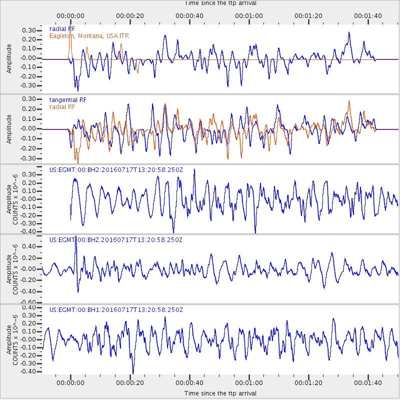
EGMT Eagleton, Montana, USA - Earthquake Result Viewer
*The percent match for this event was below the threshold and hence no stack was calculated.
| Earthquake location: |
Tonga Islands |
| Earthquake latitude/longitude: |
-17.7/-174.2 |
| Earthquake time(UTC): |
2016/07/17 (199) 13:08:53 GMT |
| Earthquake Depth: |
79 km |
| Earthquake Magnitude: |
5.6 MB |
| Earthquake Catalog/Contributor: |
NEIC PDE/NEIC ALERT |
|
| Network: |
US United States National Seismic Network |
| Station: |
EGMT Eagleton, Montana, USA |
| Lat/Lon: |
48.02 N/109.75 W |
| Elevation: |
1055 m |
|
| Distance: |
87.0 deg |
| Az: |
37.324 deg |
| Baz: |
239.445 deg |
| Ray Param: |
$rayparam |
*The percent match for this event was below the threshold and hence was not used in the summary stack. |
|
| Radial Match: |
51.55037 % |
| Radial Bump: |
400 |
| Transverse Match: |
43.35575 % |
| Transverse Bump: |
400 |
| SOD ConfigId: |
1634031 |
| Insert Time: |
2016-07-31 13:12:58.041 +0000 |
| GWidth: |
2.5 |
| Max Bumps: |
400 |
| Tol: |
0.001 |
|
Signal To Noise
| Channel | StoN | STA | LTA |
| US:EGMT:00:BHZ:20160717T13:20:58.250Z | 2.7530513 | 2.1161628E-7 | 7.686608E-8 |
| US:EGMT:00:BH1:20160717T13:20:58.250Z | 0.5527542 | 5.4487803E-8 | 9.857509E-8 |
| US:EGMT:00:BH2:20160717T13:20:58.250Z | 1.6559716 | 2.1222571E-7 | 1.2815782E-7 |
| Arrivals |
| Ps | |
| PpPs | |
| PsPs/PpSs | |


