You are here: Home > Network List > MU - Miami University Seismic Network Stations List
> Station MUH1 Harrison > Earthquake Result Viewer
MUH1 Harrison - Earthquake Result Viewer
| Earthquake location: |
Ecuador |
| Earthquake latitude/longitude: |
-2.3/-78.9 |
| Earthquake time(UTC): |
2018/09/07 (250) 02:12:04 GMT |
| Earthquake Depth: |
94 km |
| Earthquake Magnitude: |
6.2 Mww |
| Earthquake Catalog/Contributor: |
NEIC PDE/us |
|
| Network: |
MU Miami University Seismic Network |
| Station: |
MUH1 Harrison |
| Lat/Lon: |
40.23 N/81.15 W |
| Elevation: |
365 m |
|
| Distance: |
42.4 deg |
| Az: |
357.446 deg |
| Baz: |
176.666 deg |
| Ray Param: |
0.07287975 |
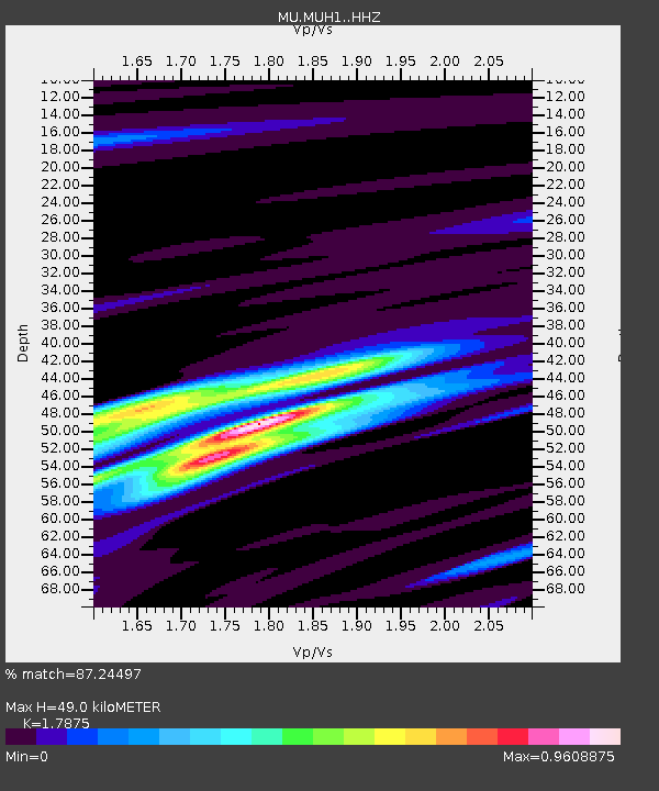
| Estimated Moho Depth: |
49.0 km |
| Estimated Crust Vp/Vs: |
1.79 |
| Assumed Crust Vp: |
6.483 km/s |
| Estimated Crust Vs: |
3.627 km/s |
| Estimated Crust Poisson's Ratio: |
0.27 |
|
| Radial Match: |
87.24497 % |
| Radial Bump: |
327 |
| Transverse Match: |
76.10507 % |
| Transverse Bump: |
400 |
| SOD ConfigId: |
13570011 |
| Insert Time: |
2019-05-01 03:55:54.753 +0000 |
| GWidth: |
2.5 |
| Max Bumps: |
400 |
| Tol: |
0.001 |
|

Signal To Noise
| Channel | StoN | STA | LTA |
| MU:MUH1: :HHZ:20180907T02:19:19.314996Z | 8.646008 | 5.4311718E-6 | 6.281711E-7 |
| MU:MUH1: :HHN:20180907T02:19:19.314996Z | 4.135282 | 2.6737443E-6 | 6.465688E-7 |
| MU:MUH1: :HHE:20180907T02:19:19.314996Z | 2.384148 | 1.2116519E-6 | 5.0821177E-7 |
| Arrivals |
| Ps | 6.4 SECOND |
| PpPs | 20 SECOND |
| PsPs/PpSs | 26 SECOND |


