You are here: Home > Network List > MU - Miami University Seismic Network Stations List
> Station MUM1 Monroe > Earthquake Result Viewer
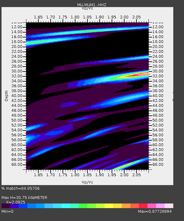
MUM1 Monroe - Earthquake Result Viewer
| Earthquake location: |
Ecuador |
| Earthquake latitude/longitude: |
-2.3/-78.9 |
| Earthquake time(UTC): |
2018/09/07 (250) 02:12:04 GMT |
| Earthquake Depth: |
94 km |
| Earthquake Magnitude: |
6.2 Mww |
| Earthquake Catalog/Contributor: |
NEIC PDE/us |
|
| Network: |
MU Miami University Seismic Network |
| Station: |
MUM1 Monroe |
| Lat/Lon: |
39.65 N/81.15 W |
| Elevation: |
310 m |
|
| Distance: |
41.8 deg |
| Az: |
357.387 deg |
| Baz: |
176.617 deg |
| Ray Param: |
0.073225625 |
| Estimated Moho Depth: |
30.75 km |
| Estimated Crust Vp/Vs: |
2.09 |
| Assumed Crust Vp: |
6.207 km/s |
| Estimated Crust Vs: |
2.966 km/s |
| Estimated Crust Poisson's Ratio: |
0.35 |
|
| Radial Match: |
84.85706 % |
| Radial Bump: |
398 |
| Transverse Match: |
66.46025 % |
| Transverse Bump: |
400 |
| SOD ConfigId: |
13570011 |
| Insert Time: |
2019-05-01 03:55:55.119 +0000 |
| GWidth: |
2.5 |
| Max Bumps: |
400 |
| Tol: |
0.001 |
|

Signal To Noise
| Channel | StoN | STA | LTA |
| MU:MUM1: :HHZ:20180907T02:19:14.629999Z | 9.469968 | 5.7412803E-6 | 6.062619E-7 |
| MU:MUM1: :HHN:20180907T02:19:14.629999Z | 5.6076527 | 3.0294775E-6 | 5.4023985E-7 |
| MU:MUM1: :HHE:20180907T02:19:14.629999Z | 1.295479 | 7.304665E-7 | 5.638582E-7 |
| Arrivals |
| Ps | 5.7 SECOND |
| PpPs | 15 SECOND |
| PsPs/PpSs | 20 SECOND |


