You are here: Home > Network List > TA - USArray Transportable Network (new EarthScope stations) Stations List
> Station S27A Los Animas, CO, USA > Earthquake Result Viewer
S27A Los Animas, CO, USA - Earthquake Result Viewer
| Earthquake location: |
Kuril Islands |
| Earthquake latitude/longitude: |
46.0/151.4 |
| Earthquake time(UTC): |
2009/04/18 (108) 19:17:58 GMT |
| Earthquake Depth: |
35 km |
| Earthquake Magnitude: |
6.3 MB, 6.3 MS, 6.6 MW, 6.4 MW |
| Earthquake Catalog/Contributor: |
WHDF/NEIC |
|
| Network: |
TA USArray Transportable Network (new EarthScope stations) |
| Station: |
S27A Los Animas, CO, USA |
| Lat/Lon: |
37.68 N/102.90 W |
| Elevation: |
1439 m |
|
| Distance: |
73.3 deg |
| Az: |
52.889 deg |
| Baz: |
315.535 deg |
| Ray Param: |
0.05303649 |
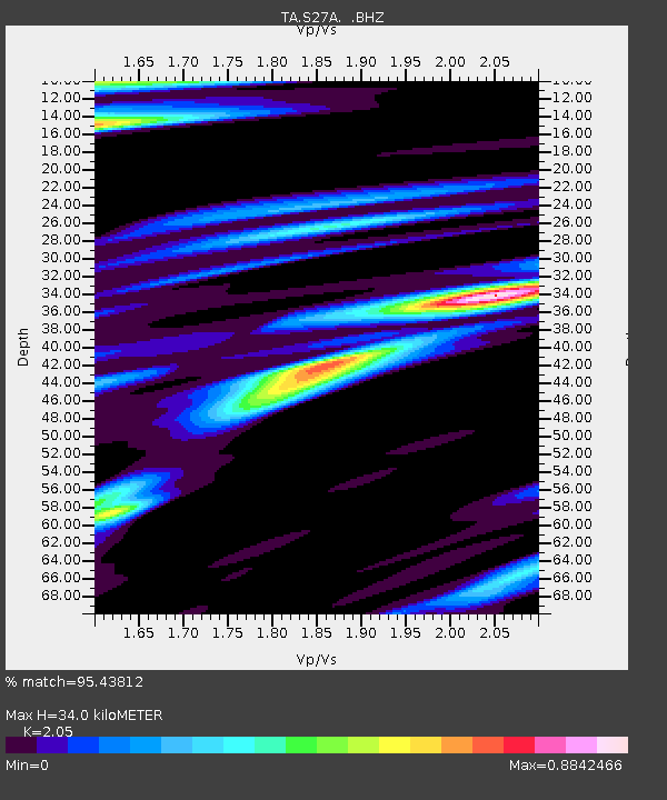
| Estimated Moho Depth: |
34.0 km |
| Estimated Crust Vp/Vs: |
2.05 |
| Assumed Crust Vp: |
6.306 km/s |
| Estimated Crust Vs: |
3.076 km/s |
| Estimated Crust Poisson's Ratio: |
0.34 |
|
| Radial Match: |
95.43812 % |
| Radial Bump: |
400 |
| Transverse Match: |
75.12738 % |
| Transverse Bump: |
400 |
| SOD ConfigId: |
2760 |
| Insert Time: |
2010-03-06 15:27:47.501 +0000 |
| GWidth: |
2.5 |
| Max Bumps: |
400 |
| Tol: |
0.001 |
|

Signal To Noise
| Channel | StoN | STA | LTA |
| TA:S27A: :BHZ:20090418T19:28:55.95002Z | 6.7674613 | 2.0687207E-6 | 3.0568637E-7 |
| TA:S27A: :BHN:20090418T19:28:55.95002Z | 0.89125204 | 9.266704E-7 | 1.0397399E-6 |
| TA:S27A: :BHE:20090418T19:28:55.95002Z | 1.2157137 | 1.0968402E-6 | 9.022191E-7 |
| Arrivals |
| Ps | 5.8 SECOND |
| PpPs | 16 SECOND |
| PsPs/PpSs | 22 SECOND |


