You are here: Home > Network List > N4 - Central and EAstern US Network Stations List
> Station V61A Roper, NC, USA > Earthquake Result Viewer
V61A Roper, NC, USA - Earthquake Result Viewer
| Earthquake location: |
Ecuador |
| Earthquake latitude/longitude: |
-2.3/-78.9 |
| Earthquake time(UTC): |
2018/09/07 (250) 02:12:04 GMT |
| Earthquake Depth: |
94 km |
| Earthquake Magnitude: |
6.2 Mww |
| Earthquake Catalog/Contributor: |
NEIC PDE/us |
|
| Network: |
N4 Central and EAstern US Network |
| Station: |
V61A Roper, NC, USA |
| Lat/Lon: |
35.79 N/76.58 W |
| Elevation: |
4.0 m |
|
| Distance: |
38.0 deg |
| Az: |
3.062 deg |
| Baz: |
183.763 deg |
| Ray Param: |
0.075506255 |
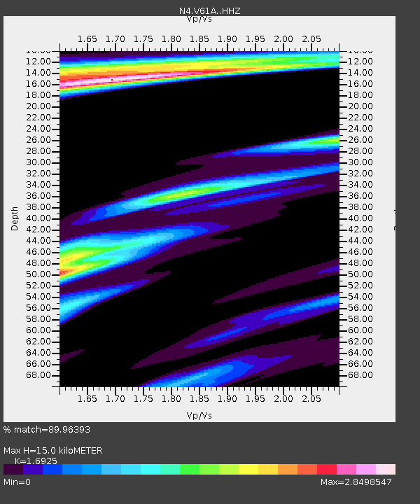
| Estimated Moho Depth: |
15.0 km |
| Estimated Crust Vp/Vs: |
1.69 |
| Assumed Crust Vp: |
6.565 km/s |
| Estimated Crust Vs: |
3.879 km/s |
| Estimated Crust Poisson's Ratio: |
0.23 |
|
| Radial Match: |
89.96393 % |
| Radial Bump: |
313 |
| Transverse Match: |
78.70577 % |
| Transverse Bump: |
387 |
| SOD ConfigId: |
13570011 |
| Insert Time: |
2019-05-01 03:57:40.167 +0000 |
| GWidth: |
2.5 |
| Max Bumps: |
400 |
| Tol: |
0.001 |
|

Signal To Noise
| Channel | StoN | STA | LTA |
| N4:V61A: :HHZ:20180907T02:18:42.90899Z | 19.293226 | 3.2326861E-6 | 1.675555E-7 |
| N4:V61A: :HHN:20180907T02:18:42.90899Z | 5.6761975 | 1.901043E-6 | 3.349149E-7 |
| N4:V61A: :HHE:20180907T02:18:42.90899Z | 3.1401646 | 9.887692E-7 | 3.1487815E-7 |
| Arrivals |
| Ps | 1.7 SECOND |
| PpPs | 5.7 SECOND |
| PsPs/PpSs | 7.4 SECOND |


