You are here: Home > Network List > N4 - Central and EAstern US Network Stations List
> Station W59A Clinton, NC, USA > Earthquake Result Viewer
W59A Clinton, NC, USA - Earthquake Result Viewer
| Earthquake location: |
Ecuador |
| Earthquake latitude/longitude: |
-2.3/-78.9 |
| Earthquake time(UTC): |
2018/09/07 (250) 02:12:04 GMT |
| Earthquake Depth: |
94 km |
| Earthquake Magnitude: |
6.2 Mww |
| Earthquake Catalog/Contributor: |
NEIC PDE/us |
|
| Network: |
N4 Central and EAstern US Network |
| Station: |
W59A Clinton, NC, USA |
| Lat/Lon: |
35.17 N/78.44 W |
| Elevation: |
60 m |
|
| Distance: |
37.3 deg |
| Az: |
0.612 deg |
| Baz: |
180.746 deg |
| Ray Param: |
0.075898446 |
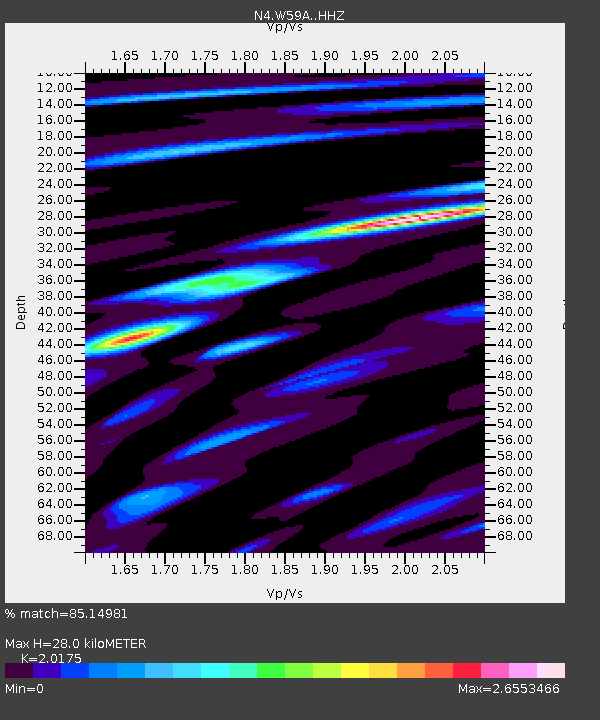
| Estimated Moho Depth: |
28.0 km |
| Estimated Crust Vp/Vs: |
2.02 |
| Assumed Crust Vp: |
6.565 km/s |
| Estimated Crust Vs: |
3.254 km/s |
| Estimated Crust Poisson's Ratio: |
0.34 |
|
| Radial Match: |
85.14981 % |
| Radial Bump: |
400 |
| Transverse Match: |
65.91559 % |
| Transverse Bump: |
400 |
| SOD ConfigId: |
13570011 |
| Insert Time: |
2019-05-01 03:57:41.756 +0000 |
| GWidth: |
2.5 |
| Max Bumps: |
400 |
| Tol: |
0.001 |
|

Signal To Noise
| Channel | StoN | STA | LTA |
| N4:W59A: :HHZ:20180907T02:18:37.179987Z | 11.591383 | 1.7208714E-6 | 1.4846127E-7 |
| N4:W59A: :HHN:20180907T02:18:37.179987Z | 19.408833 | 2.6364614E-6 | 1.3583823E-7 |
| N4:W59A: :HHE:20180907T02:18:37.179987Z | 5.157924 | 6.3659166E-7 | 1.2342012E-7 |
| Arrivals |
| Ps | 4.6 SECOND |
| PpPs | 12 SECOND |
| PsPs/PpSs | 17 SECOND |


