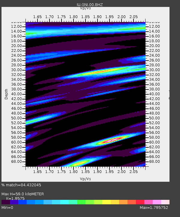
GNI Garni, Armenia - Earthquake Result Viewer

Earthquake location: Nicobar Islands, India Region
Earthquake latitude/longitude: 8.1/91.9
Earthquake time(UTC): 2009/11/10 (314) 02:48:46 GMT
Earthquake Depth: 23 km
Earthquake Magnitude: 6.1 MB, 5.7 MS, 6.0 MW, 6.0 MW
Earthquake Catalog/Contributor: WHDF/NEIC
Network: IU Global Seismograph Network (GSN - IRIS/USGS)
Station: GNI Garni, Armenia
Lat/Lon: 40.15 N/44.74 E
Elevation: 1609 m
Distance: 52.7 deg
Az: 315.057 deg
Baz: 114.139 deg
Ray Param: 0.06655069
Estimated Moho Depth: 59.0 km
Estimated Crust Vp/Vs: 1.96
Assumed Crust Vp: 6.291 km/s
Estimated Crust Vs: 3.214 km/s
Estimated Crust Poisson's Ratio: 0.32
Radial Match: 84.432045 %
Radial Bump: 400
Transverse Match: 84.69454 %
Transverse Bump: 400
SOD ConfigId: 1
Insert Time: 2010-02-19 01:10:01.150 +0000
GWidth: 2.5
Max Bumps: 400
Tol: 0.001

Signal To Noise

ChannelStoNSTALTA
IU:GNI:00:BHZ:20091110T02:57:28.647971Z5.1445033.3477022E-76.507339E-8
IU:GNI:00:BHN:20091110T02:57:28.647971Z2.1114821.3248459E-76.274484E-8
IU:GNI:00:BHE:20091110T02:57:28.647971Z0.83203296.991047E-88.402368E-8
Arrivals
Ps9.4 SECOND
PpPs26 SECOND
PsPs/PpSs36 SECOND