You are here: Home > Network List > OH - Ohio Seismic Network Stations List
> Station MWLO Mercer Wildlife Area Ohio > Earthquake Result Viewer
MWLO Mercer Wildlife Area Ohio - Earthquake Result Viewer
| Earthquake location: |
Ecuador |
| Earthquake latitude/longitude: |
-2.3/-78.9 |
| Earthquake time(UTC): |
2018/09/07 (250) 02:12:04 GMT |
| Earthquake Depth: |
94 km |
| Earthquake Magnitude: |
6.2 Mww |
| Earthquake Catalog/Contributor: |
NEIC PDE/us |
|
| Network: |
OH Ohio Seismic Network |
| Station: |
MWLO Mercer Wildlife Area Ohio |
| Lat/Lon: |
40.50 N/84.57 W |
| Elevation: |
266 m |
|
| Distance: |
43.0 deg |
| Az: |
353.649 deg |
| Baz: |
171.666 deg |
| Ray Param: |
0.072538204 |
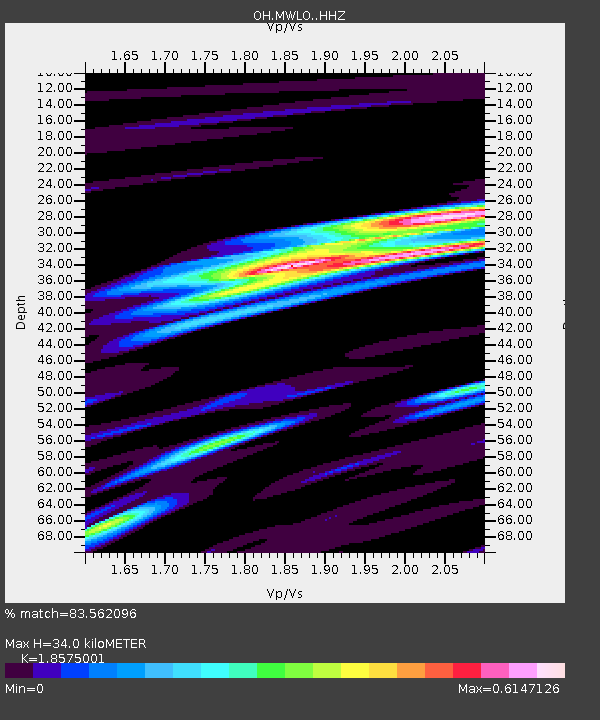
| Estimated Moho Depth: |
34.0 km |
| Estimated Crust Vp/Vs: |
1.86 |
| Assumed Crust Vp: |
6.498 km/s |
| Estimated Crust Vs: |
3.498 km/s |
| Estimated Crust Poisson's Ratio: |
0.30 |
|
| Radial Match: |
83.562096 % |
| Radial Bump: |
400 |
| Transverse Match: |
58.261917 % |
| Transverse Bump: |
400 |
| SOD ConfigId: |
13570011 |
| Insert Time: |
2019-05-01 03:58:52.132 +0000 |
| GWidth: |
2.5 |
| Max Bumps: |
400 |
| Tol: |
0.001 |
|

Signal To Noise
| Channel | StoN | STA | LTA |
| OH:MWLO: :HHZ:20180907T02:19:23.670007Z | 5.5246 | 1.312234E-6 | 2.375256E-7 |
| OH:MWLO: :HHN:20180907T02:19:23.670007Z | 5.661621 | 9.695384E-7 | 1.7124748E-7 |
| OH:MWLO: :HHE:20180907T02:19:23.670007Z | 1.4599262 | 3.8563E-7 | 2.6414347E-7 |
| Arrivals |
| Ps | 4.8 SECOND |
| PpPs | 14 SECOND |
| PsPs/PpSs | 19 SECOND |


