B12A Libby, MT, USA - Earthquake Result Viewer
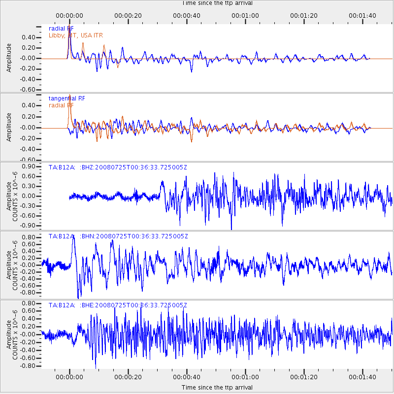
Earthquake location: Rat Islands, Aleutian Islands
Earthquake latitude/longitude: 51.3/179.0
Earthquake time(UTC): 2008/07/25 (207) 00:29:22 GMT
Earthquake Depth: 21 km
Earthquake Magnitude: 5.7 MB, 5.5 MS, 5.9 MW, 5.9 MW
Earthquake Catalog/Contributor: WHDF/NEIC
Network: TA USArray Transportable Network (new EarthScope stations)
Station: B12A Libby, MT, USA
Lat/Lon: 48.47 N/115.59 W
Elevation: 764 m
Distance: 41.0 deg
Az: 67.278 deg
Baz: 299.482 deg
Ray Param: 0.074030265
Estimated Moho Depth: 20.0 km
Estimated Crust Vp/Vs: 1.84
Assumed Crust Vp: 6.622 km/s
Estimated Crust Vs: 3.594 km/s
Estimated Crust Poisson's Ratio: 0.29
Radial Match: 80.80839 %
Radial Bump: 400
Transverse Match: 72.00254 %
Transverse Bump: 400
SOD ConfigId: 2504
Insert Time: 2010-03-06 15:28:20.083 +0000
GWidth: 2.5
Max Bumps: 400
Tol: 0.001

Signal To Noise

ChannelStoNSTALTA
TA:B12A: :BHN:20080725T00:36:33.725005Z6.22911454.801603E-77.7083236E-8
TA:B12A: :BHE:20080725T00:36:33.725005Z2.0168041.380904E-76.8469916E-8
TA:B12A: :BHZ:20080725T00:36:33.725005Z3.82867552.4716962E-76.4557476E-8
Arrivals
Ps2.7 SECOND
PpPs8.0 SECOND
PsPs/PpSs11 SECOND