You are here: Home > Network List > TA - USArray Transportable Network (new EarthScope stations) Stations List
> Station B12A Libby, MT, USA > Earthquake Result Viewer
B12A Libby, MT, USA - Earthquake Result Viewer
| Earthquake location: |
Kuril Islands |
| Earthquake latitude/longitude: |
49.9/156.4 |
| Earthquake time(UTC): |
2008/08/04 (217) 04:42:14 GMT |
| Earthquake Depth: |
77 km |
| Earthquake Magnitude: |
5.6 MB, 5.8 MW, 5.7 MW |
| Earthquake Catalog/Contributor: |
WHDF/NEIC |
|
| Network: |
TA USArray Transportable Network (new EarthScope stations) |
| Station: |
B12A Libby, MT, USA |
| Lat/Lon: |
48.47 N/115.59 W |
| Elevation: |
764 m |
|
| Distance: |
54.3 deg |
| Az: |
55.001 deg |
| Baz: |
307.18 deg |
| Ray Param: |
0.06533095 |
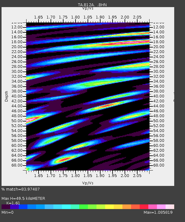
| Estimated Moho Depth: |
49.5 km |
| Estimated Crust Vp/Vs: |
1.61 |
| Assumed Crust Vp: |
6.622 km/s |
| Estimated Crust Vs: |
4.113 km/s |
| Estimated Crust Poisson's Ratio: |
0.19 |
|
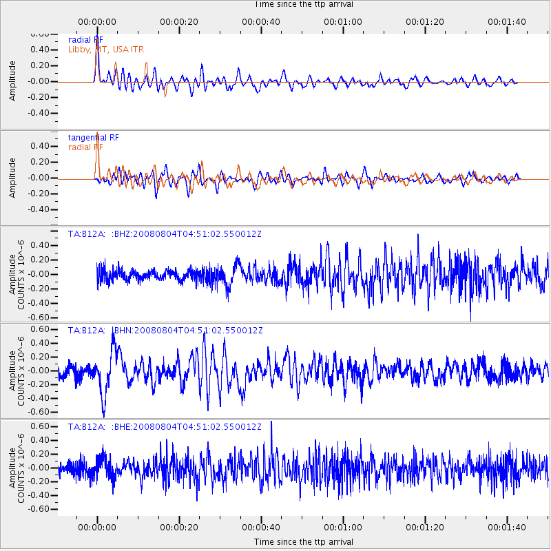
| Radial Match: |
83.97487 % |
| Radial Bump: |
400 |
| Transverse Match: |
73.16619 % |
| Transverse Bump: |
400 |
| SOD ConfigId: |
2504 |
| Insert Time: |
2010-03-06 15:28:21.745 +0000 |
| GWidth: |
2.5 |
| Max Bumps: |
400 |
| Tol: |
0.001 |
|
Signal To Noise
| Channel | StoN | STA | LTA |
| TA:B12A: :BHN:20080804T04:51:02.550012Z | 4.784191 | 3.2656112E-7 | 6.825837E-8 |
| TA:B12A: :BHE:20080804T04:51:02.550012Z | 1.9410743 | 1.4416285E-7 | 7.426962E-8 |
| TA:B12A: :BHZ:20080804T04:51:02.550012Z | 2.233902 | 1.4530802E-7 | 6.5046734E-8 |
| Arrivals |
| Ps | 4.9 SECOND |
| PpPs | 18 SECOND |
| PsPs/PpSs | 23 SECOND |


