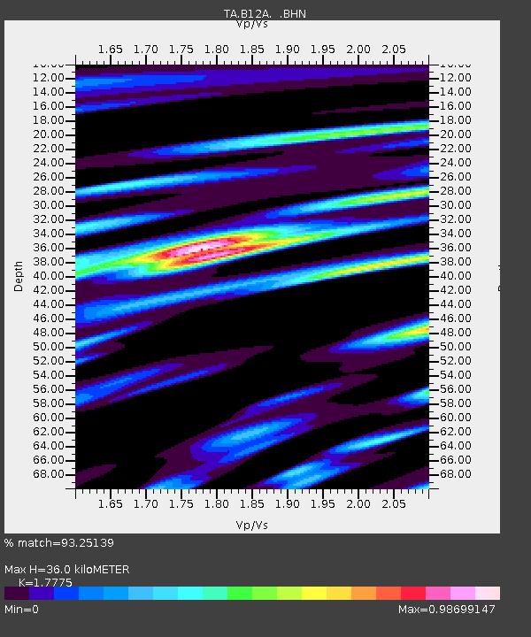
B12A Libby, MT, USA - Earthquake Result Viewer

Earthquake location: Near Coast Of Chiapas, Mexico
Earthquake latitude/longitude: 14.4/-92.4
Earthquake time(UTC): 2008/10/16 (290) 19:41:25 GMT
Earthquake Depth: 24 km
Earthquake Magnitude: 6.1 MB, 6.6 MS, 6.7 MW, 6.6 MW
Earthquake Catalog/Contributor: WHDF/NEIC
Network: TA USArray Transportable Network (new EarthScope stations)
Station: B12A Libby, MT, USA
Lat/Lon: 48.47 N/115.59 W
Elevation: 764 m
Distance: 39.0 deg
Az: 335.346 deg
Baz: 142.606 deg
Ray Param: 0.07520796
Estimated Moho Depth: 36.0 km
Estimated Crust Vp/Vs: 1.78
Assumed Crust Vp: 6.622 km/s
Estimated Crust Vs: 3.726 km/s
Estimated Crust Poisson's Ratio: 0.27
Radial Match: 93.25139 %
Radial Bump: 400
Transverse Match: 91.934296 %
Transverse Bump: 400
SOD ConfigId: 2556
Insert Time: 2010-03-06 15:28:24.388 +0000
GWidth: 2.5
Max Bumps: 400
Tol: 0.001

Signal To Noise

ChannelStoNSTALTA
TA:B12A: :BHN:20081016T19:48:19.325011Z11.6795433.6240979E-63.102945E-7
TA:B12A: :BHE:20081016T19:48:19.325011Z2.51083041.7520291E-66.977887E-7
TA:B12A: :BHZ:20081016T19:48:19.325011Z2.29007741.8065462E-67.8885813E-7
Arrivals
Ps4.6 SECOND
PpPs14 SECOND
PsPs/PpSs19 SECOND