You are here: Home > Network List > TA - USArray Transportable Network (new EarthScope stations) Stations List
> Station B12A Libby, MT, USA > Earthquake Result Viewer
B12A Libby, MT, USA - Earthquake Result Viewer

| Earthquake location: |
Tonga Islands |
| Earthquake latitude/longitude: |
-21.9/-173.8 |
| Earthquake time(UTC): |
2008/10/19 (293) 05:10:33 GMT |
| Earthquake Depth: |
29 km |
| Earthquake Magnitude: |
6.8 MB, 7.0 MS, 6.9 MW, 6.9 MW |
| Earthquake Catalog/Contributor: |
WHDF/NEIC |
|
| Network: |
TA USArray Transportable Network (new EarthScope stations) |
| Station: |
B12A Libby, MT, USA |
| Lat/Lon: |
48.47 N/115.59 W |
| Elevation: |
764 m |
|
| Distance: |
87.2 deg |
| Az: |
34.505 deg |
| Baz: |
232.252 deg |
| Ray Param: |
0.04347277 |
| Estimated Moho Depth: |
27.75 km |
| Estimated Crust Vp/Vs: |
1.61 |
| Assumed Crust Vp: |
6.622 km/s |
| Estimated Crust Vs: |
4.12 km/s |
| Estimated Crust Poisson's Ratio: |
0.18 |
|
| Radial Match: |
94.485825 % |
| Radial Bump: |
400 |
| Transverse Match: |
87.16636 % |
| Transverse Bump: |
400 |
| SOD ConfigId: |
2556 |
| Insert Time: |
2010-03-06 15:28:26.282 +0000 |
| GWidth: |
2.5 |
| Max Bumps: |
400 |
| Tol: |
0.001 |
|
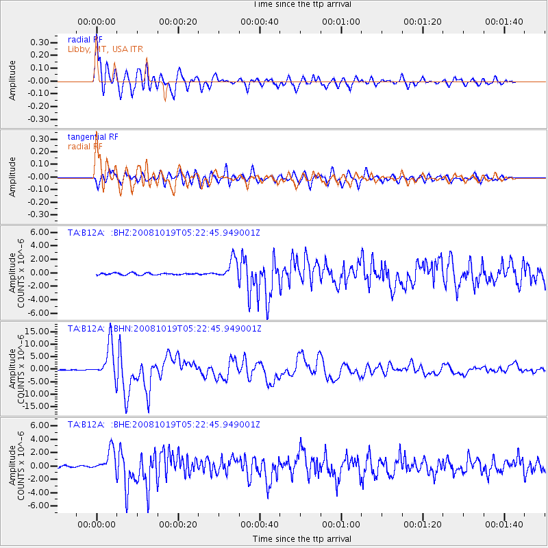
Signal To Noise
| Channel | StoN | STA | LTA |
| TA:B12A: :BHN:20081019T05:22:45.949001Z | 53.009895 | 7.200224E-6 | 1.3582792E-7 |
| TA:B12A: :BHE:20081019T05:22:45.949001Z | 10.456529 | 1.7758217E-6 | 1.69829E-7 |
| TA:B12A: :BHZ:20081019T05:22:45.949001Z | 11.963079 | 1.5613588E-6 | 1.3051479E-7 |
| Arrivals |
| Ps | 2.6 SECOND |
| PpPs | 11 SECOND |
| PsPs/PpSs | 13 SECOND |


