You are here: Home > Network List > TA - USArray Transportable Network (new EarthScope stations) Stations List
> Station B12A Libby, MT, USA > Earthquake Result Viewer
B12A Libby, MT, USA - Earthquake Result Viewer
| Earthquake location: |
Vanuatu Islands |
| Earthquake latitude/longitude: |
-14.8/168.0 |
| Earthquake time(UTC): |
2008/11/07 (312) 07:19:35 GMT |
| Earthquake Depth: |
13 km |
| Earthquake Magnitude: |
6.0 MB, 6.3 MS, 6.4 MW, 6.4 MW |
| Earthquake Catalog/Contributor: |
WHDF/NEIC |
|
| Network: |
TA USArray Transportable Network (new EarthScope stations) |
| Station: |
B12A Libby, MT, USA |
| Lat/Lon: |
48.47 N/115.59 W |
| Elevation: |
764 m |
|
| Distance: |
92.2 deg |
| Az: |
40.336 deg |
| Baz: |
250.153 deg |
| Ray Param: |
0.04149435 |
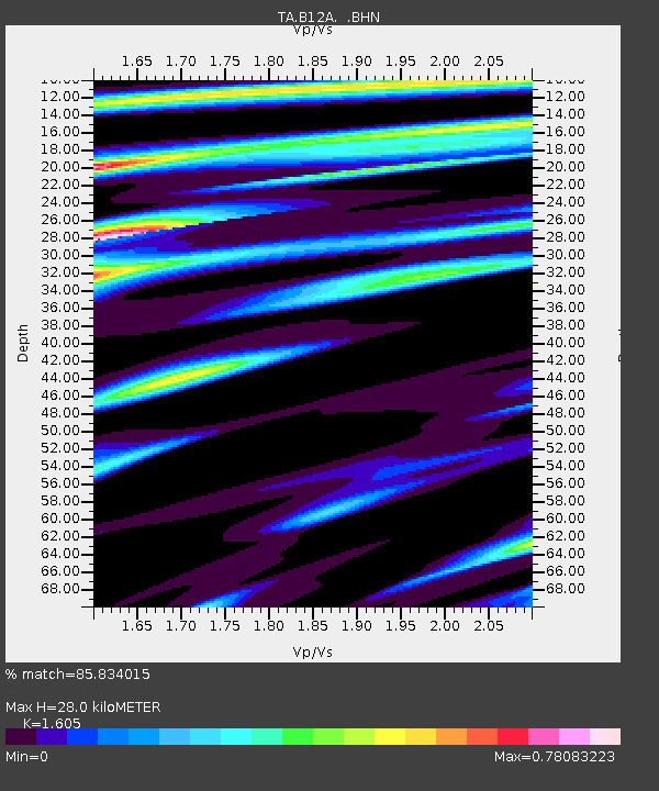
| Estimated Moho Depth: |
28.0 km |
| Estimated Crust Vp/Vs: |
1.61 |
| Assumed Crust Vp: |
6.622 km/s |
| Estimated Crust Vs: |
4.126 km/s |
| Estimated Crust Poisson's Ratio: |
0.18 |
|
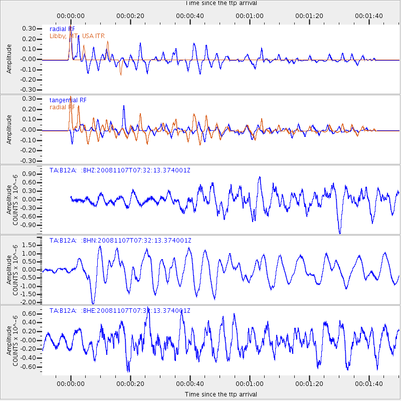
| Radial Match: |
85.834015 % |
| Radial Bump: |
361 |
| Transverse Match: |
83.36522 % |
| Transverse Bump: |
398 |
| SOD ConfigId: |
2658 |
| Insert Time: |
2010-03-06 15:28:27.360 +0000 |
| GWidth: |
2.5 |
| Max Bumps: |
400 |
| Tol: |
0.001 |
|
Signal To Noise
| Channel | StoN | STA | LTA |
| TA:B12A: :BHN:20081107T07:32:13.374001Z | 4.9888177 | 3.553689E-7 | 7.1233096E-8 |
| TA:B12A: :BHE:20081107T07:32:13.374001Z | 1.4515213 | 1.9125228E-7 | 1.3175989E-7 |
| TA:B12A: :BHZ:20081107T07:32:13.374001Z | 1.1319994 | 1.4591045E-7 | 1.2889623E-7 |
| Arrivals |
| Ps | 2.6 SECOND |
| PpPs | 11 SECOND |
| PsPs/PpSs | 13 SECOND |


