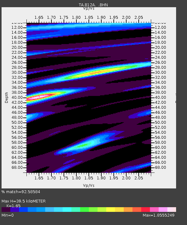
B12A Libby, MT, USA - Earthquake Result Viewer

Earthquake location: Off Coast Of Jalisco, Mexico
Earthquake latitude/longitude: 17.6/-105.5
Earthquake time(UTC): 2008/09/24 (268) 02:33:05 GMT
Earthquake Depth: 10 km
Earthquake Magnitude: 5.7 MB, 6.2 MS, 6.4 MW, 6.4 MW
Earthquake Catalog/Contributor: WHDF/NEIC
Network: TA USArray Transportable Network (new EarthScope stations)
Station: B12A Libby, MT, USA
Lat/Lon: 48.47 N/115.59 W
Elevation: 764 m
Distance: 31.9 deg
Az: 347.242 deg
Baz: 161.55 deg
Ray Param: 0.078895964
Estimated Moho Depth: 39.5 km
Estimated Crust Vp/Vs: 1.65
Assumed Crust Vp: 6.622 km/s
Estimated Crust Vs: 4.013 km/s
Estimated Crust Poisson's Ratio: 0.21
Radial Match: 92.58584 %
Radial Bump: 362
Transverse Match: 78.32047 %
Transverse Bump: 400
SOD ConfigId: 2560
Insert Time: 2010-03-06 15:28:35.491 +0000
GWidth: 2.5
Max Bumps: 400
Tol: 0.001

Signal To Noise

ChannelStoNSTALTA
TA:B12A: :BHN:20080924T02:38:59.67401Z17.1949081.4942252E-68.6899284E-8
TA:B12A: :BHE:20080924T02:38:59.67401Z10.085379.955203E-79.870935E-8
TA:B12A: :BHZ:20080924T02:38:59.67401Z4.7442575.1845313E-71.0928015E-7
Arrivals
Ps4.2 SECOND
PpPs14 SECOND
PsPs/PpSs19 SECOND