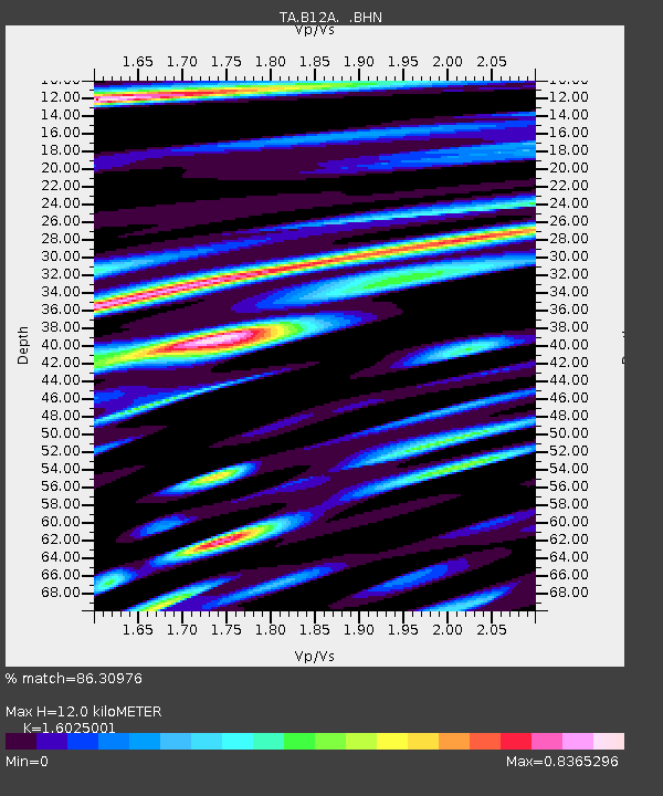
B12A Libby, MT, USA - Earthquake Result Viewer

Earthquake location: Southwestern Ryukyu Isl., Japan
Earthquake latitude/longitude: 24.2/125.1
Earthquake time(UTC): 2009/08/05 (217) 00:17:58 GMT
Earthquake Depth: 25 km
Earthquake Magnitude: 5.9 MB, 5.9 MS, 6.2 MW, 6.1 MW
Earthquake Catalog/Contributor: WHDF/NEIC
Network: TA USArray Transportable Network (new EarthScope stations)
Station: B12A Libby, MT, USA
Lat/Lon: 48.47 N/115.59 W
Elevation: 764 m
Distance: 89.6 deg
Az: 35.471 deg
Baz: 307.249 deg
Ray Param: 0.041731395
Estimated Moho Depth: 12.0 km
Estimated Crust Vp/Vs: 1.60
Assumed Crust Vp: 6.622 km/s
Estimated Crust Vs: 4.132 km/s
Estimated Crust Poisson's Ratio: 0.18
Radial Match: 86.30976 %
Radial Bump: 400
Transverse Match: 79.040726 %
Transverse Bump: 400
SOD ConfigId: 2622
Insert Time: 2010-03-06 15:28:42.531 +0000
GWidth: 2.5
Max Bumps: 400
Tol: 0.001

Signal To Noise

ChannelStoNSTALTA
TA:B12A: :BHN:20090805T00:30:22.725029Z9.9149456.755689E-76.813643E-8
TA:B12A: :BHE:20090805T00:30:22.725029Z2.38653731.9093596E-78.000544E-8
TA:B12A: :BHZ:20090805T00:30:22.725029Z2.19633651.7399394E-77.922008E-8
Arrivals
Ps1.1 SECOND
PpPs4.6 SECOND
PsPs/PpSs5.7 SECOND