You are here: Home > Network List > TA - USArray Transportable Network (new EarthScope stations) Stations List
> Station E21K Killik River, AK, USA > Earthquake Result Viewer
E21K Killik River, AK, USA - Earthquake Result Viewer
| Earthquake location: |
Ecuador |
| Earthquake latitude/longitude: |
-2.3/-78.9 |
| Earthquake time(UTC): |
2018/09/07 (250) 02:12:04 GMT |
| Earthquake Depth: |
94 km |
| Earthquake Magnitude: |
6.2 Mww |
| Earthquake Catalog/Contributor: |
NEIC PDE/us |
|
| Network: |
TA USArray Transportable Network (new EarthScope stations) |
| Station: |
E21K Killik River, AK, USA |
| Lat/Lon: |
68.44 N/153.97 W |
| Elevation: |
653 m |
|
| Distance: |
86.7 deg |
| Az: |
339.04 deg |
| Baz: |
104.746 deg |
| Ray Param: |
0.043656647 |
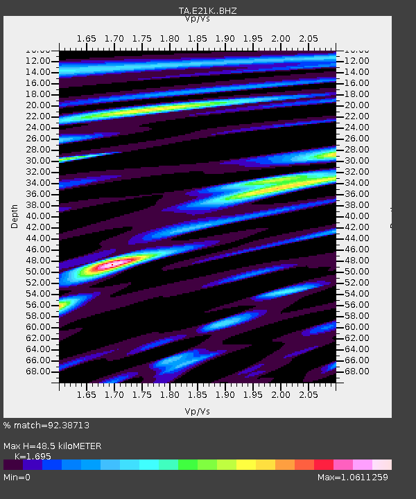
| Estimated Moho Depth: |
48.5 km |
| Estimated Crust Vp/Vs: |
1.70 |
| Assumed Crust Vp: |
6.221 km/s |
| Estimated Crust Vs: |
3.67 km/s |
| Estimated Crust Poisson's Ratio: |
0.23 |
|
| Radial Match: |
92.38713 % |
| Radial Bump: |
400 |
| Transverse Match: |
92.610695 % |
| Transverse Bump: |
400 |
| SOD ConfigId: |
13570011 |
| Insert Time: |
2019-05-01 04:00:52.233 +0000 |
| GWidth: |
2.5 |
| Max Bumps: |
400 |
| Tol: |
0.001 |
|

Signal To Noise
| Channel | StoN | STA | LTA |
| TA:E21K: :BHZ:20180907T02:24:06.675012Z | 39.182568 | 2.891618E-6 | 7.379858E-8 |
| TA:E21K: :BHN:20180907T02:24:06.675012Z | 10.34669 | 6.1861465E-7 | 5.9788654E-8 |
| TA:E21K: :BHE:20180907T02:24:06.675012Z | 11.99967 | 7.0804754E-7 | 5.9005586E-8 |
| Arrivals |
| Ps | 5.5 SECOND |
| PpPs | 21 SECOND |
| PsPs/PpSs | 26 SECOND |


