You are here: Home > Network List > TA - USArray Transportable Network (new EarthScope stations) Stations List
> Station F15K North Star Ditch, AK, USA > Earthquake Result Viewer
F15K North Star Ditch, AK, USA - Earthquake Result Viewer
| Earthquake location: |
Ecuador |
| Earthquake latitude/longitude: |
-2.3/-78.9 |
| Earthquake time(UTC): |
2018/09/07 (250) 02:12:04 GMT |
| Earthquake Depth: |
94 km |
| Earthquake Magnitude: |
6.2 Mww |
| Earthquake Catalog/Contributor: |
NEIC PDE/us |
|
| Network: |
TA USArray Transportable Network (new EarthScope stations) |
| Station: |
F15K North Star Ditch, AK, USA |
| Lat/Lon: |
65.71 N/164.65 W |
| Elevation: |
388 m |
|
| Distance: |
90.4 deg |
| Az: |
335.634 deg |
| Baz: |
94.829 deg |
| Ray Param: |
0.041660503 |
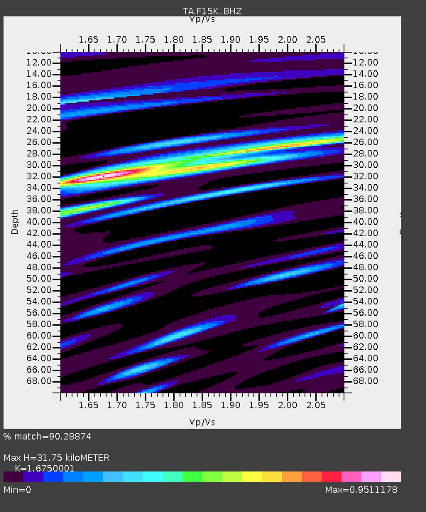
| Estimated Moho Depth: |
31.75 km |
| Estimated Crust Vp/Vs: |
1.68 |
| Assumed Crust Vp: |
6.276 km/s |
| Estimated Crust Vs: |
3.747 km/s |
| Estimated Crust Poisson's Ratio: |
0.22 |
|
| Radial Match: |
90.28874 % |
| Radial Bump: |
400 |
| Transverse Match: |
77.21777 % |
| Transverse Bump: |
400 |
| SOD ConfigId: |
13570011 |
| Insert Time: |
2019-05-01 04:00:58.821 +0000 |
| GWidth: |
2.5 |
| Max Bumps: |
400 |
| Tol: |
0.001 |
|

Signal To Noise
| Channel | StoN | STA | LTA |
| TA:F15K: :BHZ:20180907T02:24:23.875024Z | 52.910843 | 2.6171836E-6 | 4.946403E-8 |
| TA:F15K: :BHN:20180907T02:24:23.875024Z | 2.0734735 | 1.9661853E-7 | 9.482568E-8 |
| TA:F15K: :BHE:20180907T02:24:23.875024Z | 5.918105 | 8.474215E-7 | 1.4319136E-7 |
| Arrivals |
| Ps | 3.5 SECOND |
| PpPs | 13 SECOND |
| PsPs/PpSs | 17 SECOND |


