You are here: Home > Network List > TA - USArray Transportable Network (new EarthScope stations) Stations List
> Station G18K Tagagawik, AK, USA > Earthquake Result Viewer
G18K Tagagawik, AK, USA - Earthquake Result Viewer
| Earthquake location: |
Ecuador |
| Earthquake latitude/longitude: |
-2.3/-78.9 |
| Earthquake time(UTC): |
2018/09/07 (250) 02:12:04 GMT |
| Earthquake Depth: |
94 km |
| Earthquake Magnitude: |
6.2 Mww |
| Earthquake Catalog/Contributor: |
NEIC PDE/us |
|
| Network: |
TA USArray Transportable Network (new EarthScope stations) |
| Station: |
G18K Tagagawik, AK, USA |
| Lat/Lon: |
65.89 N/158.65 W |
| Elevation: |
484 m |
|
| Distance: |
87.9 deg |
| Az: |
336.145 deg |
| Baz: |
100.299 deg |
| Ray Param: |
0.042761847 |
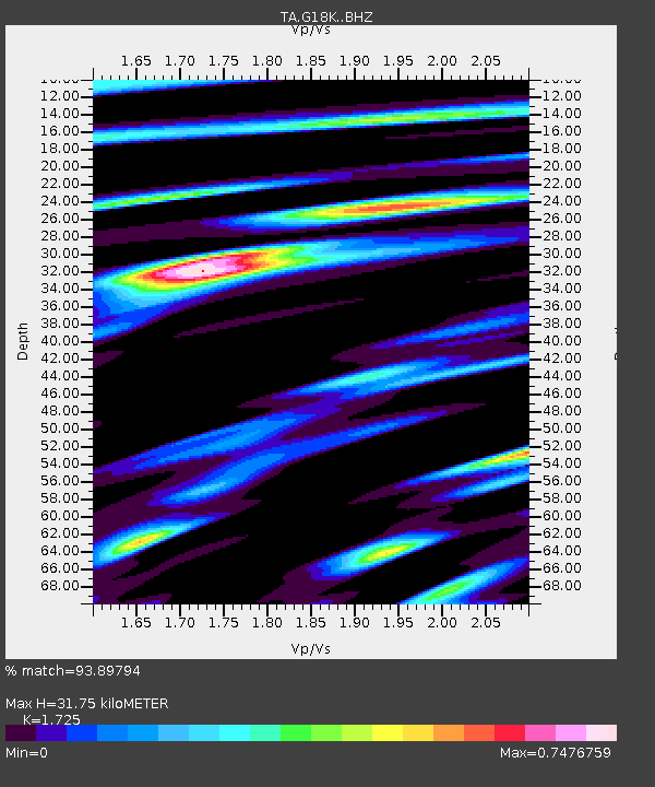
| Estimated Moho Depth: |
31.75 km |
| Estimated Crust Vp/Vs: |
1.73 |
| Assumed Crust Vp: |
6.1 km/s |
| Estimated Crust Vs: |
3.536 km/s |
| Estimated Crust Poisson's Ratio: |
0.25 |
|
| Radial Match: |
93.89794 % |
| Radial Bump: |
400 |
| Transverse Match: |
91.801445 % |
| Transverse Bump: |
388 |
| SOD ConfigId: |
13570011 |
| Insert Time: |
2019-05-01 04:01:12.065 +0000 |
| GWidth: |
2.5 |
| Max Bumps: |
400 |
| Tol: |
0.001 |
|

Signal To Noise
| Channel | StoN | STA | LTA |
| TA:G18K: :BHZ:20180907T02:24:12.574976Z | 52.663815 | 3.07291E-6 | 5.8349553E-8 |
| TA:G18K: :BHN:20180907T02:24:12.574976Z | 5.0660176 | 2.9231512E-7 | 5.7701165E-8 |
| TA:G18K: :BHE:20180907T02:24:12.574976Z | 17.159412 | 8.277945E-7 | 4.824143E-8 |
| Arrivals |
| Ps | 3.9 SECOND |
| PpPs | 14 SECOND |
| PsPs/PpSs | 18 SECOND |


