You are here: Home > Network List > TA - USArray Transportable Network (new EarthScope stations) Stations List
> Station G30M túh Zraii Njik, YT, CAN > Earthquake Result Viewer
G30M túh Zraii Njik, YT, CAN - Earthquake Result Viewer
| Earthquake location: |
Ecuador |
| Earthquake latitude/longitude: |
-2.3/-78.9 |
| Earthquake time(UTC): |
2018/09/07 (250) 02:12:04 GMT |
| Earthquake Depth: |
94 km |
| Earthquake Magnitude: |
6.2 Mww |
| Earthquake Catalog/Contributor: |
NEIC PDE/us |
|
| Network: |
TA USArray Transportable Network (new EarthScope stations) |
| Station: |
G30M túh Zraii Njik, YT, CAN |
| Lat/Lon: |
66.98 N/136.22 W |
| Elevation: |
739 m |
|
| Distance: |
79.9 deg |
| Az: |
340.354 deg |
| Baz: |
121.328 deg |
| Ray Param: |
0.048415612 |
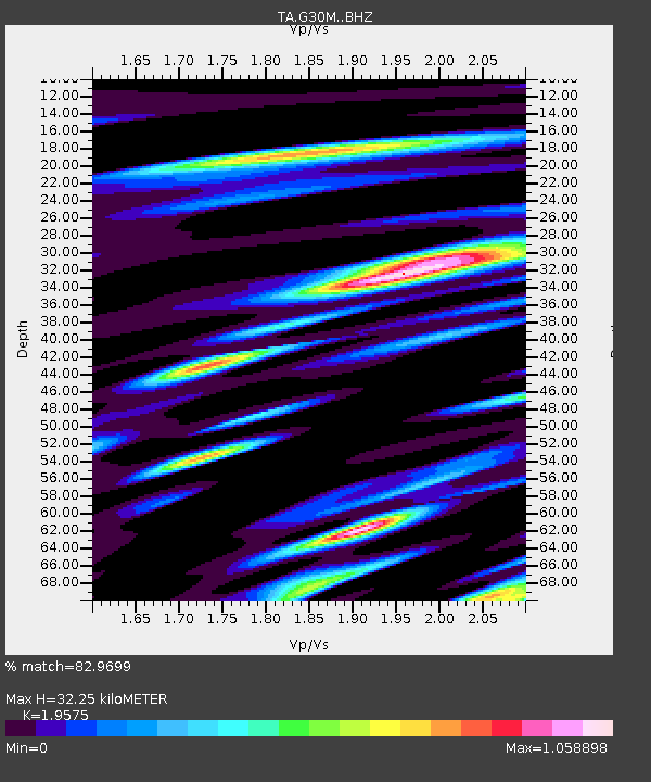
| Estimated Moho Depth: |
32.25 km |
| Estimated Crust Vp/Vs: |
1.96 |
| Assumed Crust Vp: |
6.522 km/s |
| Estimated Crust Vs: |
3.332 km/s |
| Estimated Crust Poisson's Ratio: |
0.32 |
|
| Radial Match: |
82.9699 % |
| Radial Bump: |
400 |
| Transverse Match: |
75.03625 % |
| Transverse Bump: |
400 |
| SOD ConfigId: |
13570011 |
| Insert Time: |
2019-05-01 04:01:18.667 +0000 |
| GWidth: |
2.5 |
| Max Bumps: |
400 |
| Tol: |
0.001 |
|

Signal To Noise
| Channel | StoN | STA | LTA |
| TA:G30M: :BHZ:20180907T02:23:32.050012Z | 17.733318 | 2.005874E-6 | 1.13113295E-7 |
| TA:G30M: :BHN:20180907T02:23:32.050012Z | 2.79336 | 2.5516363E-7 | 9.13465E-8 |
| TA:G30M: :BHE:20180907T02:23:32.050012Z | 10.04857 | 9.651521E-7 | 9.604871E-8 |
| Arrivals |
| Ps | 4.9 SECOND |
| PpPs | 14 SECOND |
| PsPs/PpSs | 19 SECOND |


