You are here: Home > Network List > TA - USArray Transportable Network (new EarthScope stations) Stations List
> Station L16K Owhat River, AK, USA > Earthquake Result Viewer
L16K Owhat River, AK, USA - Earthquake Result Viewer
| Earthquake location: |
Ecuador |
| Earthquake latitude/longitude: |
-2.3/-78.9 |
| Earthquake time(UTC): |
2018/09/07 (250) 02:12:04 GMT |
| Earthquake Depth: |
94 km |
| Earthquake Magnitude: |
6.2 Mww |
| Earthquake Catalog/Contributor: |
NEIC PDE/us |
|
| Network: |
TA USArray Transportable Network (new EarthScope stations) |
| Station: |
L16K Owhat River, AK, USA |
| Lat/Lon: |
61.71 N/159.47 W |
| Elevation: |
227 m |
|
| Distance: |
87.6 deg |
| Az: |
331.94 deg |
| Baz: |
99.399 deg |
| Ray Param: |
0.043028004 |
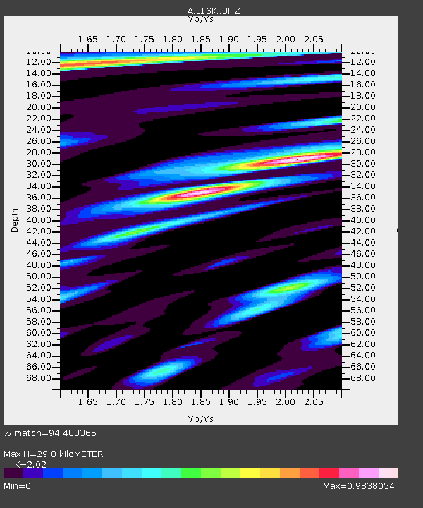
| Estimated Moho Depth: |
29.0 km |
| Estimated Crust Vp/Vs: |
2.02 |
| Assumed Crust Vp: |
6.276 km/s |
| Estimated Crust Vs: |
3.107 km/s |
| Estimated Crust Poisson's Ratio: |
0.34 |
|
| Radial Match: |
94.488365 % |
| Radial Bump: |
400 |
| Transverse Match: |
89.19369 % |
| Transverse Bump: |
400 |
| SOD ConfigId: |
13570011 |
| Insert Time: |
2019-05-01 04:01:52.782 +0000 |
| GWidth: |
2.5 |
| Max Bumps: |
400 |
| Tol: |
0.001 |
|

Signal To Noise
| Channel | StoN | STA | LTA |
| TA:L16K: :BHZ:20180907T02:24:10.850Z | 32.77953 | 2.6976597E-6 | 8.2297085E-8 |
| TA:L16K: :BHN:20180907T02:24:10.850Z | 4.771857 | 2.976693E-7 | 6.2380174E-8 |
| TA:L16K: :BHE:20180907T02:24:10.850Z | 13.934433 | 8.0357387E-7 | 5.7668217E-8 |
| Arrivals |
| Ps | 4.8 SECOND |
| PpPs | 14 SECOND |
| PsPs/PpSs | 19 SECOND |


