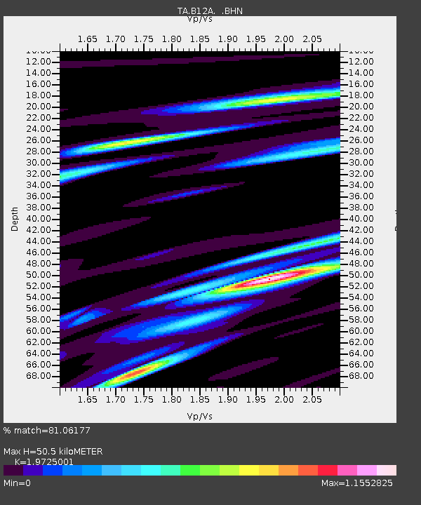
B12A Libby, MT, USA - Earthquake Result Viewer

Earthquake location: Andreanof Islands, Aleutian Is.
Earthquake latitude/longitude: 51.3/-180.0
Earthquake time(UTC): 2007/08/02 (214) 03:21:42 GMT
Earthquake Depth: 21 km
Earthquake Magnitude: 6.3 MB, 6.6 MS, 6.7 MW, 6.6 MW
Earthquake Catalog/Contributor: WHDF/NEIC
Network: TA USArray Transportable Network (new EarthScope stations)
Station: B12A Libby, MT, USA
Lat/Lon: 48.47 N/115.59 W
Elevation: 764 m
Distance: 40.4 deg
Az: 67.831 deg
Baz: 299.136 deg
Ray Param: 0.07440213
Estimated Moho Depth: 50.5 km
Estimated Crust Vp/Vs: 1.97
Assumed Crust Vp: 6.622 km/s
Estimated Crust Vs: 3.357 km/s
Estimated Crust Poisson's Ratio: 0.33
Radial Match: 81.06177 %
Radial Bump: 400
Transverse Match: 76.16533 %
Transverse Bump: 400
SOD ConfigId: 2564
Insert Time: 2010-03-06 15:29:10.459 +0000
GWidth: 2.5
Max Bumps: 400
Tol: 0.001

Signal To Noise

ChannelStoNSTALTA
TA:B12A: :BHN:20070802T03:28:48.473015Z0.94524996.330518E-76.6971893E-7
TA:B12A: :BHE:20070802T03:28:48.473015Z4.077322.0656141E-65.066108E-7
TA:B12A: :BHZ:20070802T03:28:48.473015Z2.3899672.231111E-69.335322E-7
Arrivals
Ps7.9 SECOND
PpPs21 SECOND
PsPs/PpSs29 SECOND